Tolcayuca night lights from space
Night Light of Tolcayuca (Hidalgo) from space (Mexico) Src. Average luminocity for 10x10km area is 21.0649% and for 50x50km: 35.2978%.
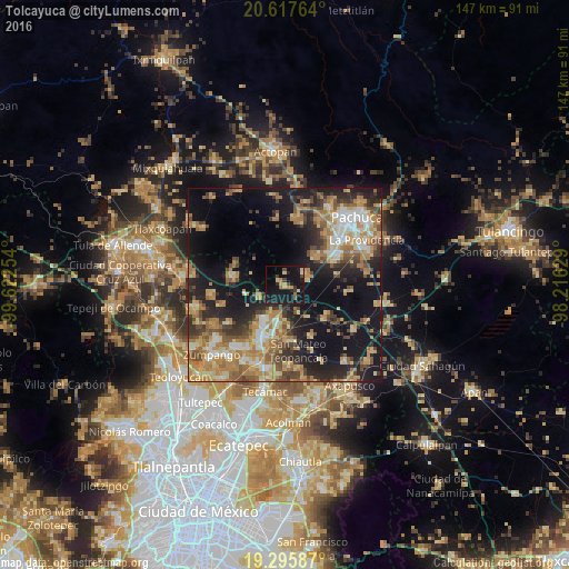
Analysis of Tolcayuca night lights 2016
Square area 10x10 km:
 0%
0%90-99
0%80-89
5.41%70-79
3.03%60-69
2.6%50-59
1.3%40-49
2.6%30-39
3.25%20-29
5.41%10-19
50.43%0-9
25.97%Square area 50x50 km:
3.13%90-99
4.05%80-89
6.03%70-79
7.03%60-69
8.22%50-59
3.94%40-49
5.58%30-39
4.87%20-29
8.83%10-19
22.67%0-9
25.65%Clear (daylight) street map image can be seen on geolist.org.
Map coordinates:
20° 37' 3.5" North, 99° 37' 21.1" West
19° 57' 29.3" North, 98° 55' 9.9" West
19° 17' 45.1" North, 98° 12' 58.6" West
Some cities around Tolcayuca sort by population:
• Tizayuca
14.7 km =9.1 mi,  203°
203°
• Don Antonio
9.4 km =5.8 mi,  189°
189°
• Santa María Ajoloapan
13.3 km =8.3 mi,  279°
279°
• Acayuca
11.1 km =6.9 mi,  47°
47°
• San Francisco Zacacalco
7.4 km =4.6 mi,  243°
243°
• Temascalapa
14.6 km =9.1 mi,  172°
172°
• Tezontepec
13.5 km =8.4 mi,  129°
129°
• Huitzila
16.8 km =10.4 mi, 193°
3515321 (p: 6,836)
Sources (retrieved 2019-11-25):
» Earth at Night: Flat Maps 2012, 2016