Acayuca night lights from space
Night Light of Acayuca (Hidalgo) from space (Mexico) Src. Average luminocity for 10x10km area is 40.5258% and for 50x50km: 29.3072%.
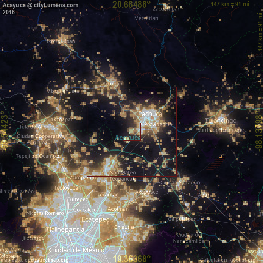
Analysis of Acayuca night lights 2016
Square area 10x10 km:
 4.37%
4.37%90-99
3.37%80-89
8.33%70-79
6.94%60-69
7.74%50-59
3.77%40-49
8.13%30-39
5.16%20-29
13.49%10-19
31.15%0-9
7.54%Square area 50x50 km:
2.54%90-99
2.94%80-89
4.8%70-79
4.7%60-69
5.73%50-59
3.25%40-49
5.25%30-39
5.36%20-29
8.09%10-19
25.45%0-9
31.9%Clear (daylight) street map image can be seen on geolist.org.
Map coordinates:
20° 41' 5.6" North, 99° 32' 39.2" West
20° 1' 32.4" North, 98° 50' 28" West
19° 21' 49.2" North, 98° 8' 16.7" West
Some cities around Acayuca sort by population:
• Pachuca de Soto
15.2 km =9.4 mi,  47°
47°
• La Providencia Siglo XXI
13.6 km =8.5 mi,  71°
71°
• San Agustín Tlaxiaca
11 km =6.8 mi,  334°
334°
• Tolcayuca
11.1 km =6.9 mi,  227°
227°
• Campestre Villas del Álamo
16.3 km =10.1 mi,  58°
58°
• Pachuquilla
16 km =9.9 mi, 71°
• Unidad Minera 11 de Julio
15.2 km =9.4 mi, 54°
• Los Tuzos
9.4 km =5.8 mi, 70°
3533428 (p: 8,470)
Sources (retrieved 2019-11-25):
» Earth at Night: Flat Maps 2012, 2016