Santa María Ixtulco night lights from space
Night Light of Santa María Ixtulco (Tlaxcala) from space (Mexico) Src. Average luminocity for 10x10km area is 83.1818% and for 50x50km: 40.5817%.
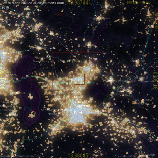
Analysis of Santa María Ixtulco night lights 2016
Square area 10x10 km:
 17.98%
90-99
20.87%80-89
23.97%70-79
21.9%60-69
4.55%50-59
5.17%40-49
4.75%30-39
0.83%20-29
0%10-19
0%0-9
0%Square area 50x50 km:
2.65%90-99
4.51%80-89
12.34%70-79
8.65%60-69
7.26%50-59
6.16%40-49
7.47%30-39
4.52%20-29
5.5%10-19
10.39%0-9
30.55%Clear (daylight) street map image can be seen on geolist.org.
Map coordinates:
19° 59' 14.8" North, 98° 54' 41.6" West
19° 19' 31" North, 98° 12' 30.3" West
18° 39' 37.6" North, 97° 30' 19.1" West
Some cities around Santa María Ixtulco sort by population:
• Tlaxcala
1.1 km =0.7 mi,  127°
127°
• Contla
4.4 km =2.7 mi,  84°
84°
• La Magdalena Tlaltelulco
4.9 km =3 mi,  164°
164°
• Acuitlapilco
6.4 km =4 mi,  206°
206°
• Amaxac de Guerrero
4.6 km =2.9 mi,  59°
59°
• Apetatitlán Antonio Carbajal
3.3 km =2.1 mi,  68°
68°
• Totolac
5.2 km =3.2 mi,  270°
270°
• San Esteban Tizatlán
1.6 km =1 mi,  340°
340°
3815382 (p: 5,293)
Sources (retrieved 2019-11-25):
» Earth at Night: Flat Maps 2012, 2016