Totolac night lights from space
Night Light of Totolac (Tlaxcala) from space (Mexico) Src. Average luminocity for 10x10km area is 70.7417% and for 50x50km: 42.9522%.
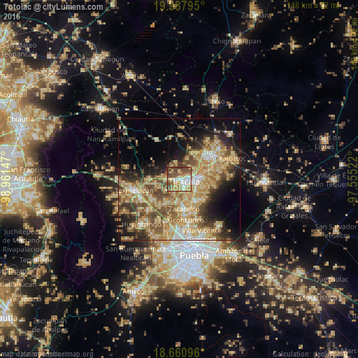
Analysis of Totolac night lights 2016
Square area 10x10 km:
 9.71%
9.71%90-99
13.22%80-89
15.29%70-79
15.5%60-69
9.5%50-59
13.84%40-49
19.42%30-39
3.51%20-29
0%10-19
0%0-9
0%Square area 50x50 km:
2.67%90-99
4.64%80-89
13.08%70-79
9.15%60-69
8.02%50-59
6.62%40-49
8.07%30-39
5.08%20-29
6.38%10-19
9.45%0-9
26.86%Clear (daylight) street map image can be seen on geolist.org.
Map coordinates:
19° 59' 16.6" North, 98° 57' 41.3" West
19° 19' 32.9" North, 98° 15' 30" West
18° 39' 39.5" North, 97° 33' 18.8" West
Some cities around Totolac sort by population:
• Tlaxcala
6.2 km =3.9 mi,  96°
96°
• Santa Ana Chiautempan
7.7 km =4.8 mi,  106°
106°
• La Magdalena Tlaltelulco
8.1 km =5 mi,  126°
126°
• Acuitlapilco
6.3 km =3.9 mi,  157°
157°
• Panotla
1.6 km =1 mi,  229°
229°
• San Esteban Tizatlán
4.9 km =3 mi,  72°
72°
• Santa María Ixtulco
5.2 km =3.2 mi,  90°
90°
• San Damián Texoloc
6 km =3.7 mi,  208°
208°
3815419 (p: 6,989)
Sources (retrieved 2019-11-25):
» Earth at Night: Flat Maps 2012, 2016