La Magdalena Tlaltelulco night lights from space
Night Light of La Magdalena Tlaltelulco (Tlaxcala) from space (Mexico) Src. Average luminocity for 10x10km area is 84.0455% and for 50x50km: 46.4487%.
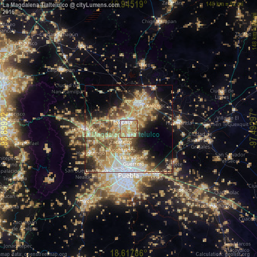
Analysis of La Magdalena Tlaltelulco night lights 2016
Square area 10x10 km:
 11.9%
11.9%90-99
16.45%80-89
35.28%70-79
29%60-69
6.06%50-59
0.87%40-49
0.43%30-39
0%20-29
0%10-19
0%0-9
0%Square area 50x50 km:
5.45%90-99
5.82%80-89
13.19%70-79
9.19%60-69
7.35%50-59
6.75%40-49
7.99%30-39
4.65%20-29
6.16%10-19
10.63%0-9
22.82%Clear (daylight) street map image can be seen on geolist.org.
Map coordinates:
19° 56' 42.7" North, 98° 53' 57.2" West
19° 16' 58.3" North, 98° 11' 45.9" West
18° 37' 4.3" North, 97° 29' 34.7" West
Some cities around La Magdalena Tlaltelulco sort by population:
• Tlaxcala
4 km =2.5 mi,  354°
354°
• Santa Ana Chiautempan
2.8 km =1.7 mi,  18°
18°
• Contla
6 km =3.7 mi,  31°
31°
• Teolocholco
4.4 km =2.7 mi,  172°
172°
• Acuitlapilco
4.3 km =2.7 mi,  255°
255°
• San Francisco Tetlanohcan
4.2 km =2.6 mi,  126°
126°
• Tetlanohcán
4.2 km =2.6 mi, 126°
• Santa María Ixtulco
4.9 km =3 mi,  344°
344°
3815375 (p: 16,834)
Sources (retrieved 2019-11-25):
» Earth at Night: Flat Maps 2012, 2016