Acuitlapilco night lights from space
Night Light of Acuitlapilco (Tlaxcala) from space (Mexico) Src. Average luminocity for 10x10km area is 81.7965% and for 50x50km: 49.0542%.
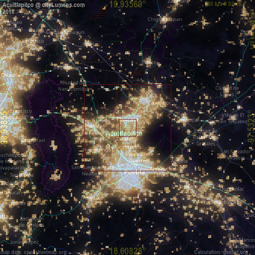
Analysis of Acuitlapilco night lights 2016
Square area 10x10 km:
 10.17%
90-99
11.04%80-89
33.33%70-79
34.42%60-69
8.66%50-59
2.38%40-49
0%30-39
0%20-29
0%10-19
0%0-9
0%Square area 50x50 km:
6.2%90-99
6.33%80-89
13.75%70-79
9.47%60-69
7.85%50-59
6.89%40-49
8.19%30-39
5.29%20-29
6.71%10-19
10.14%0-9
19.17%Clear (daylight) street map image can be seen on geolist.org.
Map coordinates:
19° 56' 8.5" North, 98° 56' 18.8" West
19° 16' 24" North, 98° 14' 7.5" West
18° 36' 29.8" North, 97° 31' 56.3" West
Some cities around Acuitlapilco sort by population:
• Tlaxcala
6.3 km =3.9 mi,  36°
36°
• Santa Ana Chiautempan
6.2 km =3.9 mi,  53°
53°
• La Magdalena Tlaltelulco
4.3 km =2.7 mi,  75°
75°
• Teolocholco
5.7 km =3.5 mi,  125°
125°
• Panotla
6 km =3.7 mi,  322°
322°
• San Juan Huactzinco
4.8 km =3 mi,  202°
202°
• San Damián Texoloc
5.3 km =3.3 mi,  276°
276°
• San Lorenzo Axocomanitla
5.7 km =3.5 mi,  194°
194°
3533380 (p: 13,386)
Sources (retrieved 2019-11-25):
» Earth at Night: Flat Maps 2012, 2016