San Esteban Tizatlán night lights from space
Night Light of San Esteban Tizatlán (Tlaxcala) from space (Mexico) Src. Average luminocity for 10x10km area is 79.8099% and for 50x50km: 39.1598%.
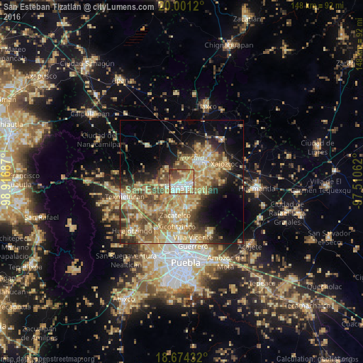
Analysis of San Esteban Tizatlán night lights 2016
Square area 10x10 km:
 17.56%
90-99
18.8%80-89
21.28%70-79
16.53%60-69
6.82%50-59
8.88%40-49
7.02%30-39
2.89%20-29
0.21%10-19
0%0-9
0%Square area 50x50 km:
2.32%90-99
4.12%80-89
12.02%70-79
8.42%60-69
7.12%50-59
6.21%40-49
7.29%30-39
4.38%20-29
5.31%10-19
9.93%0-9
32.89%Clear (daylight) street map image can be seen on geolist.org.
Map coordinates:
20° 0' 4.3" North, 98° 55' 0.7" West
19° 20' 20.8" North, 98° 12' 49.5" West
18° 40' 27.6" North, 97° 30' 38.2" West
Some cities around San Esteban Tizatlán sort by population:
• Tlaxcala
2.7 km =1.7 mi,  146°
146°
• Santa Ana Chiautempan
4.5 km =2.8 mi,  142°
142°
• Contla
5.1 km =3.2 mi,  102°
102°
• Amaxac de Guerrero
4.6 km =2.9 mi,  79°
79°
• Panotla
6.4 km =4 mi,  246°
246°
• Apetatitlán Antonio Carbajal
3.6 km =2.2 mi, 95°
• Totolac
4.9 km =3 mi, 252°
• Santa María Ixtulco
1.6 km =1 mi,  160°
160°
3519455 (p: 6,114)
Sources (retrieved 2019-11-25):
» Earth at Night: Flat Maps 2012, 2016