Amaxac de Guerrero night lights from space
Night Light of Amaxac de Guerrero (Tlaxcala) from space (Mexico) Src. Average luminocity for 10x10km area is 79.5331% and for 50x50km: 36.3964%.
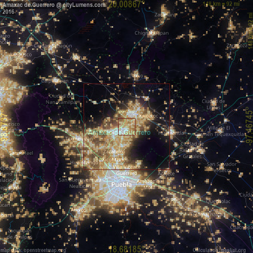
Analysis of Amaxac de Guerrero night lights 2016
Square area 10x10 km:
 9.92%
9.92%90-99
11.78%80-89
26.65%70-79
28.51%60-69
16.32%50-59
5.17%40-49
1.65%30-39
0%20-29
0%10-19
0%0-9
0%Square area 50x50 km:
1.97%90-99
3.56%80-89
11.07%70-79
8.04%60-69
6.56%50-59
5.84%40-49
7.03%30-39
3.66%20-29
4.79%10-19
10.88%0-9
36.61%Clear (daylight) street map image can be seen on geolist.org.
Map coordinates:
20° 0' 31.2" North, 98° 52' 25.3" West
19° 20' 47.8" North, 98° 10' 14.1" West
18° 40' 54.7" North, 97° 28' 2.8" West
Some cities around Amaxac de Guerrero sort by population:
• Tlaxcala
4.3 km =2.7 mi,  225°
225°
• Santa Ana Chiautempan
4.8 km =3 mi,  202°
202°
• Contla
2 km =1.2 mi,  167°
167°
• Santa Anita Huiloac
5.4 km =3.4 mi,  31°
31°
• Apetatitlán Antonio Carbajal
1.5 km =0.9 mi,  217°
217°
• San Esteban Tizatlán
4.6 km =2.9 mi,  259°
259°
• San Miguel Contla
4.3 km =2.7 mi,  68°
68°
• Santa María Ixtulco
4.6 km =2.9 mi,  239°
239°
3519622 (p: 9,114)
Sources (retrieved 2019-11-25):
» Earth at Night: Flat Maps 2012, 2016