San Pedro Tultepec night lights from space
Night Light of San Pedro Tultepec (Morelos) from space (Mexico) Src. Average luminocity for 10x10km area is 74.3139% and for 50x50km: 45.4911%.
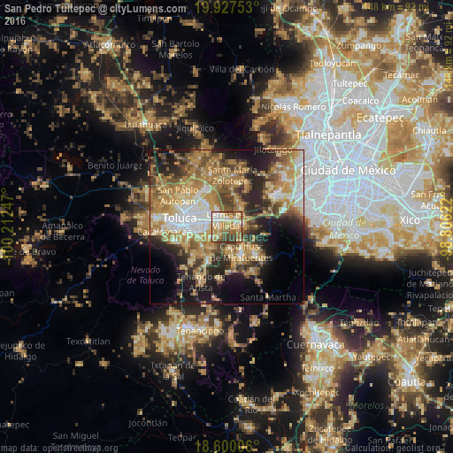
Analysis of San Pedro Tultepec night lights 2016
Square area 10x10 km:
 8.23%
8.23%90-99
16.88%80-89
17.1%70-79
17.32%60-69
18.83%50-59
9.74%40-49
7.14%30-39
4.76%20-29
0%10-19
0%0-9
0%Square area 50x50 km:
5.83%90-99
5.81%80-89
8.09%70-79
9.56%60-69
11.71%50-59
6.02%40-49
6.57%30-39
5.21%20-29
9.25%10-19
11.73%0-9
20.22%Clear (daylight) street map image can be seen on geolist.org.
Map coordinates:
19° 55' 39.1" North, 100° 12' 44.9" West
19° 15' 54.5" North, 99° 30' 33.6" West
18° 36' 0.2" North, 98° 48' 22.4" West
Some cities around San Pedro Tultepec sort by population:
• San Mateo Atenco
2.4 km =1.5 mi,  276°
276°
• Ocoyoacac
5.4 km =3.4 mi,  82°
82°
• Lerma de Villada
2.6 km =1.6 mi,  354°
354°
• Santa María Atarasquillo
8.2 km =5.1 mi,  31°
31°
• El Cerrillo Vista Hermosa
7.4 km =4.6 mi,  331°
331°
• San Gaspar Tlahuelilpan
4.5 km =2.8 mi,  237°
237°
• Atizapán
4.6 km =2.9 mi,  248°
248°
• San Miguel Ameyalco
7 km =4.3 mi,  48°
48°
3827267 (p: 13,634)
Sources (retrieved 2019-11-25):
» Earth at Night: Flat Maps 2012, 2016