El Cerrillo Vista Hermosa night lights from space
Night Light of El Cerrillo Vista Hermosa (México) from space (Mexico) Src. Average luminocity for 10x10km area is 76.4236% and for 50x50km: 46.4846%.
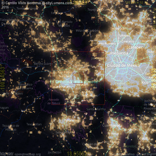
Analysis of El Cerrillo Vista Hermosa night lights 2016
Square area 10x10 km:
 20.45%
90-99
21.69%80-89
5.99%70-79
14.67%60-69
9.71%50-59
13.43%40-49
5.99%30-39
8.06%20-29
0%10-19
0%0-9
0%Square area 50x50 km:
4.88%90-99
5.03%80-89
8.14%70-79
9.82%60-69
12.95%50-59
6.88%40-49
7.73%30-39
6.01%20-29
10.53%10-19
13.33%0-9
14.69%Clear (daylight) street map image can be seen on geolist.org.
Map coordinates:
19° 59' 7.9" North, 100° 14' 44.3" West
19° 19' 24.1" North, 99° 32' 33" West
18° 39' 30.7" North, 98° 50' 21.8" West
Some cities around El Cerrillo Vista Hermosa sort by population:
• San Mateo Atenco
6.3 km =3.9 mi,  170°
170°
• San José Guadalupe Otzacatipan
5.7 km =3.5 mi,  294°
294°
• Lerma de Villada
5 km =3.1 mi,  139°
139°
• San Pedro Totoltepec
3.4 km =2.1 mi,  246°
246°
• Santa María Totoltepec
5.6 km =3.5 mi, 250°
• San Nicolás Tolentino
5 km =3.1 mi,  322°
322°
• La Constitución Toltepec
2.9 km =1.8 mi,  345°
345°
• San Miguel Totoltepec
3.7 km =2.3 mi,  271°
271°
3827257 (p: 8,699)
Sources (retrieved 2019-11-25):
» Earth at Night: Flat Maps 2012, 2016