San Gaspar Tlahuelilpan night lights from space
Night Light of San Gaspar Tlahuelilpan (Morelos) from space (Mexico) Src. Average luminocity for 10x10km area is 73.8074% and for 50x50km: 43.5321%.
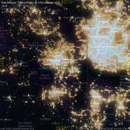
Analysis of San Gaspar Tlahuelilpan night lights 2016
Square area 10x10 km:
 9.09%
9.09%90-99
15.37%80-89
12.12%70-79
25.76%60-69
15.58%50-59
8.01%40-49
8.01%30-39
6.06%20-29
0%10-19
0%0-9
0%Square area 50x50 km:
4.8%90-99
4.93%80-89
7.96%70-79
9.25%60-69
11.86%50-59
5.8%40-49
6.79%30-39
5.28%20-29
9.6%10-19
11.73%0-9
21.99%Clear (daylight) street map image can be seen on geolist.org.
Map coordinates:
19° 54' 19.4" North, 100° 14' 55.7" West
19° 14' 34.4" North, 99° 32' 44.4" West
18° 34' 39.8" North, 98° 50' 33.2" West
Some cities around San Gaspar Tlahuelilpan sort by population:
• San Mateo Atenco
3.1 km =1.9 mi,  27°
27°
• San Salvador Tizatlalli
5.1 km =3.2 mi,  292°
292°
• Lerma de Villada
6.2 km =3.9 mi, 34°
• San Pedro Tultepec
4.5 km =2.8 mi,  57°
57°
• Mexicaltzingo
5.4 km =3.4 mi,  229°
229°
• San Miguel Totocuitlapilco
5.3 km =3.3 mi,  252°
252°
• Atizapán
0.9 km =0.6 mi,  330°
330°
• Chapultepec
4.8 km =3 mi,  200°
200°
3817591 (p: 8,456)
Sources (retrieved 2019-11-25):
» Earth at Night: Flat Maps 2012, 2016