Atizapán night lights from space
Night Light of Atizapán (México) from space (Mexico) Src. Average luminocity for 10x10km area is 78.2121% and for 50x50km: 43.6016%.
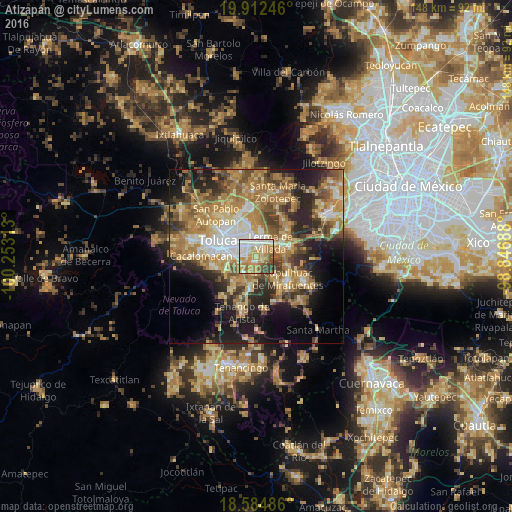
Analysis of Atizapán night lights 2016
Square area 10x10 km:
 14.5%
14.5%90-99
20.78%80-89
11.04%70-79
24.24%60-69
12.34%50-59
7.14%40-49
5.19%30-39
4.76%20-29
0%10-19
0%0-9
0%Square area 50x50 km:
4.76%90-99
4.89%80-89
7.89%70-79
9.17%60-69
11.94%50-59
6.06%40-49
6.91%30-39
5.38%20-29
9.49%10-19
12.07%0-9
21.42%Clear (daylight) street map image can be seen on geolist.org.
Map coordinates:
19° 54' 44.9" North, 100° 15' 11.3" West
19° 15' 0" North, 99° 33' 0" West
18° 35' 5.5" North, 98° 50' 48.8" West
Some cities around Atizapán sort by population:
• San Mateo Atenco
2.7 km =1.7 mi,  43°
43°
• San Salvador Tizatlalli
4.4 km =2.7 mi,  284°
284°
• Metepec
5.5 km =3.4 mi, 280°
• San Pedro Tultepec
4.6 km =2.9 mi,  68°
68°
• Mexicaltzingo
5.6 km =3.5 mi,  220°
220°
• San Gaspar Tlahuelilpan
0.9 km =0.6 mi,  150°
150°
• San Miguel Totocuitlapilco
5.2 km =3.2 mi,  243°
243°
• Chapultepec
5.5 km =3.4 mi,  193°
193°
3532625 (p: 7,243)
Sources (retrieved 2019-11-25):
» Earth at Night: Flat Maps 2012, 2016