San Miguel Ameyalco night lights from space
Night Light of San Miguel Ameyalco (Morelos) from space (Mexico) Src. Average luminocity for 10x10km area is 56.4459% and for 50x50km: 49.9801%.
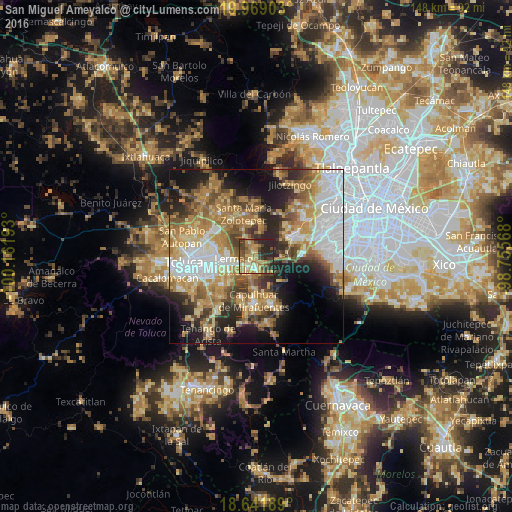
Analysis of San Miguel Ameyalco night lights 2016
Square area 10x10 km:
 2.38%
2.38%90-99
6.06%80-89
12.55%70-79
9.96%60-69
19.7%50-59
7.58%40-49
11.26%30-39
9.74%20-29
20.78%10-19
0%0-9
0%Square area 50x50 km:
10.55%90-99
6.61%80-89
7.65%70-79
9.38%60-69
10.82%50-59
6.15%40-49
6.71%30-39
5.34%20-29
9.25%10-19
11.44%0-9
16.1%Clear (daylight) street map image can be seen on geolist.org.
Map coordinates:
19° 58' 8.5" North, 100° 9' 42.9" West
19° 18' 24.5" North, 99° 27' 31.7" West
18° 38' 30.8" North, 98° 45' 20.4" West
Some cities around San Miguel Ameyalco sort by population:
• Ocoyoacac
4 km =2.5 mi,  178°
178°
• Lerma de Villada
5.9 km =3.7 mi,  250°
250°
• Santa María Atarasquillo
2.6 km =1.6 mi,  335°
335°
• San Pedro Tultepec
7 km =4.3 mi,  228°
228°
• San Pedro Cholula
5.5 km =3.4 mi,  211°
211°
• San Pedro Chochula
5.6 km =3.5 mi, 210°
• El Cerrillo Vista Hermosa
9 km =5.6 mi,  281°
281°
• La Constitución Toltepec
10.6 km =6.6 mi,  296°
296°
3532895 (p: 5,387)
Sources (retrieved 2019-11-25):
» Earth at Night: Flat Maps 2012, 2016