San Pedro Chochula night lights from space
Night Light of San Pedro Chochula (Morelos) from space (Mexico) Src. Average luminocity for 10x10km area is 66.1277% and for 50x50km: 46.2973%.
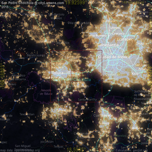
Analysis of San Pedro Chochula night lights 2016
Square area 10x10 km:
 4.11%
4.11%90-99
9.09%80-89
15.15%70-79
13.2%60-69
23.38%50-59
9.96%40-49
13.42%30-39
11.69%20-29
0%10-19
0%0-9
0%Square area 50x50 km:
7.73%90-99
5.91%80-89
7.89%70-79
9.27%60-69
10.85%50-59
5.88%40-49
6.42%30-39
4.98%20-29
9.04%10-19
11.74%0-9
20.29%Clear (daylight) street map image can be seen on geolist.org.
Map coordinates:
19° 55' 33.6" North, 100° 11' 20.5" West
19° 15' 48.9" North, 99° 29' 9.2" West
18° 35' 54.6" North, 98° 46' 58" West
Some cities around San Pedro Chochula sort by population:
• San Mateo Atenco
4.9 km =3 mi,  275°
275°
• Ocoyoacac
3.1 km =1.9 mi,  73°
73°
• Lerma de Villada
3.9 km =2.4 mi,  316°
316°
• Santa María Atarasquillo
7.4 km =4.6 mi,  13°
13°
• San Gaspar Tlahuelilpan
6.7 km =4.2 mi,  249°
249°
• Atizapán
6.9 km =4.3 mi,  257°
257°
• San Miguel Ameyalco
5.6 km =3.5 mi,  30°
30°
• San Mateo Atarasquíllo
7.1 km =4.4 mi,  21°
21°
3530756 (p: 8,798)
Sources (retrieved 2019-11-25):
» Earth at Night: Flat Maps 2012, 2016