San Mateo Atarasquíllo night lights from space
Night Light of San Mateo Atarasquíllo (Morelos) from space (Mexico) Src. Average luminocity for 10x10km area is 53.0558% and for 50x50km: 50.792%.
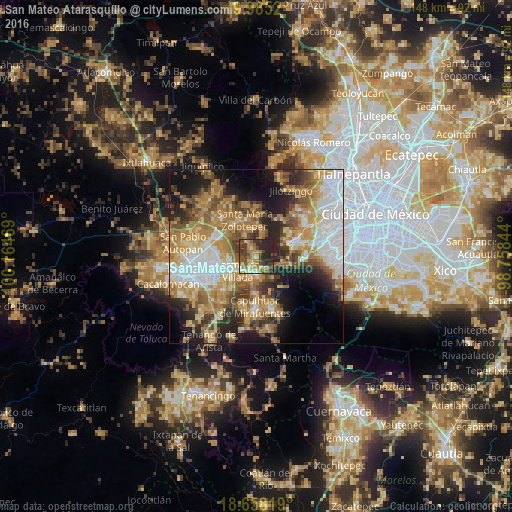
Analysis of San Mateo Atarasquíllo night lights 2016
Square area 10x10 km:
 2.07%
2.07%90-99
5.17%80-89
10.12%70-79
8.47%60-69
16.94%50-59
9.5%40-49
11.78%30-39
11.78%20-29
24.17%10-19
0%0-9
0%Square area 50x50 km:
10.4%90-99
6.65%80-89
8.02%70-79
9.61%60-69
11.07%50-59
6.33%40-49
6.94%30-39
5.52%20-29
9.58%10-19
11.49%0-9
14.38%Clear (daylight) street map image can be seen on geolist.org.
Map coordinates:
19° 59' 6.7" North, 100° 9' 52.9" West
19° 19' 22.9" North, 99° 27' 41.6" West
18° 39' 29.5" North, 98° 45' 30.4" West
Some cities around San Mateo Atarasquíllo sort by population:
• Ocoyoacac
5.8 km =3.6 mi,  176°
176°
• Lerma de Villada
6.5 km =4 mi,  234°
234°
• Santa María Atarasquillo
1 km =0.6 mi,  306°
306°
• San Pedro Tultepec
8.2 km =5.1 mi,  217°
217°
• San Pedro Cholula
7 km =4.3 mi,  201°
201°
• San Pedro Chochula
7.1 km =4.4 mi, 201°
• El Cerrillo Vista Hermosa
8.5 km =5.3 mi,  270°
270°
• La Constitución Toltepec
9.6 km =6 mi,  287°
287°
3827368 (p: 5,273)
Sources (retrieved 2019-11-25):
» Earth at Night: Flat Maps 2012, 2016