San Miguel Totocuitlapilco night lights from space
Night Light of San Miguel Totocuitlapilco (México) from space (Mexico) Src. Average luminocity for 10x10km area is 78.7078% and for 50x50km: 41.7503%.
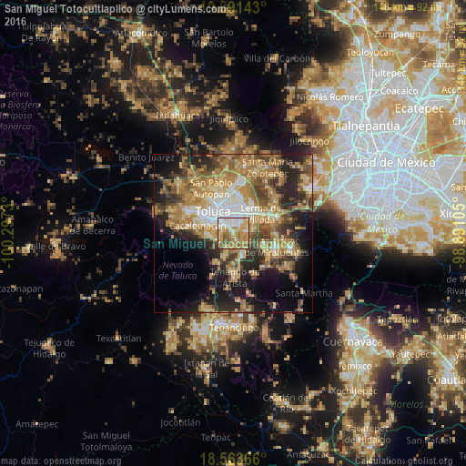
Analysis of San Miguel Totocuitlapilco night lights 2016
Square area 10x10 km:
 13.2%
13.2%90-99
16.45%80-89
14.5%70-79
28.14%60-69
14.94%50-59
9.31%40-49
3.03%30-39
0.43%20-29
0%10-19
0%0-9
0%Square area 50x50 km:
4.37%90-99
4.39%80-89
7.71%70-79
8.43%60-69
11.57%50-59
5.63%40-49
6.49%30-39
5.66%20-29
9.96%10-19
12.69%0-9
23.09%Clear (daylight) street map image can be seen on geolist.org.
Map coordinates:
19° 53' 29.1" North, 100° 17' 50.3" West
19° 13' 44" North, 99° 35' 39" West
18° 33' 49.2" North, 98° 53' 27.8" West
Some cities around San Miguel Totocuitlapilco sort by population:
• San Salvador Tizatlalli
3.5 km =2.2 mi,  5°
5°
• Metepec
3.5 km =2.2 mi,  346°
346°
• San Bartolomé Tlaltelulco
3.7 km =2.3 mi,  267°
267°
• Mexicaltzingo
2.2 km =1.4 mi,  153°
153°
• Santa María Magdalena Ocotitlán
3.3 km =2.1 mi,  286°
286°
• Santa María Nativitas
4.2 km =2.6 mi,  242°
242°
• Chapultepec
4.5 km =2.8 mi,  131°
131°
• San Andrés Ocotlán
4.1 km =2.5 mi,  168°
168°
3827264 (p: 8,207)
Sources (retrieved 2019-11-25):
» Earth at Night: Flat Maps 2012, 2016