Mexicaltzingo night lights from space
Night Light of Mexicaltzingo (México) from space (Mexico) Src. Average luminocity for 10x10km area is 71.4048% and for 50x50km: 42.1015%.
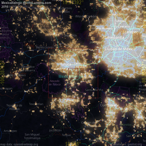
Analysis of Mexicaltzingo night lights 2016
Square area 10x10 km:
 4.76%
4.76%90-99
9.52%80-89
12.77%70-79
30.74%60-69
21.43%50-59
10.82%40-49
6.49%30-39
2.38%20-29
1.08%10-19
0%0-9
0%Square area 50x50 km:
4.47%90-99
4.53%80-89
7.95%70-79
8.56%60-69
11.39%50-59
5.66%40-49
6.38%30-39
5.73%20-29
9.83%10-19
12.4%0-9
23.1%Clear (daylight) street map image can be seen on geolist.org.
Map coordinates:
19° 52' 26.1" North, 100° 17' 16.2" West
19° 12' 40.7" North, 99° 35' 4.9" West
18° 32' 45.6" North, 98° 52' 53.7" West
Some cities around Mexicaltzingo sort by population:
• San Bartolomé Tlaltelulco
5 km =3.1 mi,  290°
290°
• San Gaspar Tlahuelilpan
5.4 km =3.4 mi,  49°
49°
• Ex-Rancho San Dimas
4.6 km =2.9 mi,  153°
153°
• San Miguel Totocuitlapilco
2.2 km =1.4 mi,  333°
333°
• Santa María Magdalena Ocotitlán
5 km =3.1 mi,  304°
304°
• Santa María Nativitas
4.7 km =2.9 mi,  270°
270°
• Chapultepec
2.6 km =1.6 mi,  112°
112°
• San Andrés Ocotlán
2 km =1.2 mi,  184°
184°
3518377 (p: 9,693)
Sources (retrieved 2019-11-25):
» Earth at Night: Flat Maps 2012, 2016