Chapultepec night lights from space
Night Light of Chapultepec (México) from space (Mexico) Src. Average luminocity for 10x10km area is 63.3939% and for 50x50km: 42.8661%.
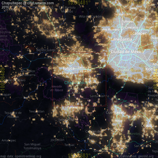
Analysis of Chapultepec night lights 2016
Square area 10x10 km:
 1.52%
1.52%90-99
6.49%80-89
11.26%70-79
23.59%60-69
20.78%50-59
9.74%40-49
10.39%30-39
8.23%20-29
8.01%10-19
0%0-9
0%Square area 50x50 km:
4.81%90-99
4.97%80-89
8.28%70-79
8.88%60-69
11.17%50-59
5.54%40-49
6.22%30-39
5.7%20-29
9.45%10-19
11.73%0-9
23.26%Clear (daylight) street map image can be seen on geolist.org.
Map coordinates:
19° 51' 53.3" North, 100° 15' 53.6" West
19° 12' 7.8" North, 99° 33' 42.3" West
18° 32' 12.6" North, 98° 51' 31.1" West
Some cities around Chapultepec sort by population:
• San Antonio la Isla
4.2 km =2.6 mi,  187°
187°
• Mexicaltzingo
2.6 km =1.6 mi,  292°
292°
• Santa María Rayón
6.3 km =3.9 mi,  197°
197°
• San Gaspar Tlahuelilpan
4.8 km =3 mi,  20°
20°
• Ex-Rancho San Dimas
3.2 km =2 mi, 186°
• San Miguel Totocuitlapilco
4.5 km =2.8 mi,  311°
311°
• Atizapán
5.5 km =3.4 mi,  13°
13°
• San Andrés Ocotlán
2.8 km =1.7 mi,  248°
248°
3518280 (p: 6,004)
Sources (retrieved 2019-11-25):
» Earth at Night: Flat Maps 2012, 2016