Nuevo Ideal night lights from space
Night Light of Nuevo Ideal (Durango) from space (Mexico) Src. Average luminocity for 10x10km area is 6.3068% and for 50x50km: 0.5975%.
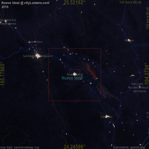
Analysis of Nuevo Ideal night lights 2016
Square area 10x10 km:
 0%
0%90-99
0%80-89
2.27%70-79
2.27%60-69
0.38%50-59
1.14%40-49
1.52%30-39
0%20-29
0%10-19
0.38%0-9
92.05%Square area 50x50 km:
0%90-99
0%80-89
0.09%70-79
0.11%60-69
0.06%50-59
0.25%40-49
0.23%30-39
0.12%20-29
0.12%10-19
0.06%0-9
98.95%Clear (daylight) street map image can be seen on geolist.org.
Map coordinates:
25° 31' 17.8" North, 105° 46' 43.1" West
24° 53' 7.6" North, 105° 4' 31.9" West
24° 14' 45.5" North, 104° 22' 20.6" West
Some cities around Nuevo Ideal sort by population:
• Victoria de Durango
105.1 km =65.3 mi,  156°
156°
• Santiago Papasquiaro
38.9 km =24.2 mi,  296°
296°
• El Salto
126.5 km =78.6 mi,  193°
193°
• Ciudad Guadalupe Victoria
108.2 km =67.2 mi,  116°
116°
• Canatlán
50.3 km =31.3 mi,  142°
142°
• Santa María del Oro
121.8 km =75.7 mi,  346°
346°
• Peñón Blanco
106.3 km =66.1 mi,  95°
95°
• Tayoltita
122.7 km =76.2 mi,  224°
224°
3994607 (p: 10,876)
Sources (retrieved 2019-11-25):
» Earth at Night: Flat Maps 2012, 2016