Canatlán night lights from space
Night Light of Canatlán (Durango) from space (Mexico) Src. Average luminocity for 10x10km area is 6.2321% and for 50x50km: 0.4282%.
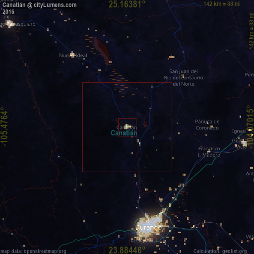
Analysis of Canatlán night lights 2016
Square area 10x10 km:
 0%
0%90-99
0.2%80-89
1.98%70-79
2.58%60-69
0%50-59
1.59%40-49
0.79%30-39
0.79%20-29
0%10-19
0%0-9
92.06%Square area 50x50 km:
0%90-99
0.04%80-89
0.08%70-79
0.1%60-69
0%50-59
0.13%40-49
0.12%30-39
0.07%20-29
0.11%10-19
0.05%0-9
99.3%Clear (daylight) street map image can be seen on geolist.org.
Map coordinates:
25° 9' 49.7" North, 105° 28' 35" West
24° 31' 32.7" North, 104° 46' 23.8" West
23° 53' 4.1" North, 104° 4' 12.5" West
Some cities around Canatlán sort by population:
• Victoria de Durango
57.4 km =35.7 mi,  168°
168°
• Santiago Papasquiaro
87 km =54.1 mi,  311°
311°
• El Salto
102.4 km =63.6 mi,  215°
215°
• Ciudad Guadalupe Victoria
66.6 km =41.4 mi,  97°
97°
• Nuevo Ideal
50.3 km =31.3 mi,  322°
322°
• Villa Unión
95.8 km =59.5 mi,  129°
129°
• Nombre de Dios
92.3 km =57.4 mi,  144°
144°
• Peñón Blanco
81.1 km =50.4 mi,  68°
68°
4015683 (p: 11,495)
Sources (retrieved 2019-11-25):
» Earth at Night: Flat Maps 2012, 2016