Miacatlán night lights from space
Night Light of Miacatlán (Morelos) from space (Mexico) Src. Average luminocity for 10x10km area is 32.1157% and for 50x50km: 28.6019%.
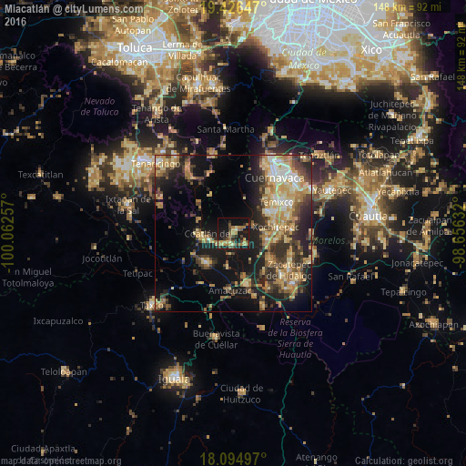
Analysis of Miacatlán night lights 2016
Square area 10x10 km:
 0%
0%90-99
0%80-89
6.61%70-79
6.61%60-69
9.09%50-59
6.61%40-49
6.4%30-39
3.31%20-29
7.23%10-19
36.57%0-9
17.56%Square area 50x50 km:
1.37%90-99
3.13%80-89
5.82%70-79
5.63%60-69
5.72%50-59
3.01%40-49
5.54%30-39
5.18%20-29
8.13%10-19
16.92%0-9
39.55%Clear (daylight) street map image can be seen on geolist.org.
Map coordinates:
19° 25' 35.3" North, 100° 3' 45.3" West
18° 45' 43.3" North, 99° 21' 34" West
18° 5' 41.9" North, 98° 39' 22.8" West
Some cities around Miacatlán sort by population:
• Puente de Ixtla
16.9 km =10.5 mi,  165°
165°
• Xoxocotla
14.8 km =9.2 mi,  125°
125°
• Xochitepec
13.7 km =8.5 mi,  81°
81°
• La Joya
15.5 km =9.6 mi,  226°
226°
• Unidad Habitacional José María Morelos y Pavón
12.1 km =7.5 mi,  57°
57°
• Coatetelco
5 km =3.1 mi,  135°
135°
• Alpuyeca
10.8 km =6.7 mi,  103°
103°
• Chiconcuac
16.2 km =10.1 mi, 81°
3523247 (p: 7,212)
Sources (retrieved 2019-11-25):
» Earth at Night: Flat Maps 2012, 2016