Coatetelco night lights from space
Night Light of Coatetelco (Morelos) from space (Mexico) Src. Average luminocity for 10x10km area is 28.8595% and for 50x50km: 26.3929%.
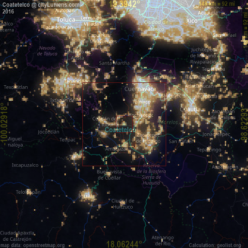
Analysis of Coatetelco night lights 2016
Square area 10x10 km:
 0%
0%90-99
0%80-89
5.79%70-79
4.55%60-69
5.79%50-59
5.17%40-49
5.79%30-39
1.65%20-29
10.12%10-19
58.47%0-9
2.69%Square area 50x50 km:
1.24%90-99
2.71%80-89
5.25%70-79
4.98%60-69
4.91%50-59
2.88%40-49
5.43%30-39
4.98%20-29
8.03%10-19
16.33%0-9
43.27%Clear (daylight) street map image can be seen on geolist.org.
Map coordinates:
19° 23' 39.1" North, 100° 1' 45" West
18° 43' 46.7" North, 99° 19' 33.8" West
18° 3' 44.8" North, 98° 37' 22.5" West
Some cities around Coatetelco sort by population:
• Puente de Ixtla
12.8 km =8 mi,  176°
176°
• Xoxocotla
9.9 km =6.2 mi,  120°
120°
• Xochitepec
11.6 km =7.2 mi,  60°
60°
• Unidad Habitacional José María Morelos y Pavón
12.1 km =7.5 mi,  33°
33°
• Alpuyeca
7.1 km =4.4 mi,  80°
80°
• Miacatlán
5 km =3.1 mi,  315°
315°
• Chiconcuac
13.8 km =8.6 mi, 64°
• Amacuzac
15.3 km =9.5 mi,  197°
197°
3530523 (p: 9,094)
Sources (retrieved 2019-11-25):
» Earth at Night: Flat Maps 2012, 2016