Alpuyeca night lights from space
Night Light of Alpuyeca (Morelos) from space (Mexico) Src. Average luminocity for 10x10km area is 46.3347% and for 50x50km: 28.3281%.
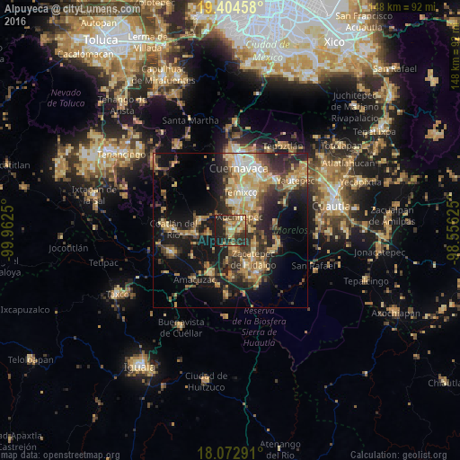
Analysis of Alpuyeca night lights 2016
Square area 10x10 km:
 0.83%
0.83%90-99
3.31%80-89
8.47%70-79
9.71%60-69
15.29%50-59
6.61%40-49
7.23%30-39
11.16%20-29
18.39%10-19
19.01%0-9
0%Square area 50x50 km:
1.36%90-99
2.9%80-89
5.87%70-79
5.6%60-69
5.26%50-59
2.92%40-49
5.69%30-39
5.21%20-29
8.75%10-19
16.93%0-9
39.51%Clear (daylight) street map image can be seen on geolist.org.
Map coordinates:
19° 24' 16.5" North, 99° 57' 45" West
18° 44' 24.2" North, 99° 15' 33.7" West
18° 4' 22.5" North, 98° 33' 22.5" West
Some cities around Alpuyeca sort by population:
• Zacatepec
12 km =7.5 mi,  142°
142°
• Xoxocotla
6.4 km =4 mi,  167°
167°
• Xochitepec
5.5 km =3.4 mi,  33°
33°
• Santa Rosa Treinta
9.1 km =5.7 mi,  119°
119°
• Unidad Habitacional José María Morelos y Pavón
8.9 km =5.5 mi,  358°
358°
• Coatetelco
7.1 km =4.4 mi,  260°
260°
• Miacatlán
10.8 km =6.7 mi,  283°
283°
• Chiconcuac
7.3 km =4.5 mi,  49°
49°
3533020 (p: 8,330)
Sources (retrieved 2019-11-25):
» Earth at Night: Flat Maps 2012, 2016