La Joya night lights from space
Night Light of La Joya (Morelos) from space (Mexico) Src. Average luminocity for 10x10km area is 20.0496% and for 50x50km: 14.857%.
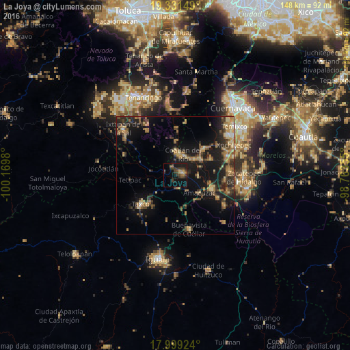
Analysis of La Joya night lights 2016
Square area 10x10 km:
 0.62%
0.62%90-99
0.21%80-89
2.48%70-79
4.13%60-69
1.65%50-59
1.65%40-49
8.26%30-39
7.64%20-29
4.13%10-19
15.7%0-9
53.51%Square area 50x50 km:
0.19%90-99
0.58%80-89
2.67%70-79
2.3%60-69
3.31%50-59
1.92%40-49
2.98%30-39
3.44%20-29
4.89%10-19
13.51%0-9
64.21%Clear (daylight) street map image can be seen on geolist.org.
Map coordinates:
19° 19' 53.4" North, 100° 10' 11.3" West
18° 40' 0" North, 99° 28' 0" West
17° 59' 57.3" North, 98° 45' 48.8" West
Some cities around La Joya sort by population:
• Taxco de Alarcón
19.2 km =11.9 mi,  229°
229°
• Puente de Ixtla
16.7 km =10.4 mi,  110°
110°
• Coatetelco
16.4 km =10.2 mi,  64°
64°
• Alpuyeca
23.3 km =14.5 mi,  69°
69°
• Miacatlán
15.5 km =9.6 mi,  46°
46°
• Tlamacazapa
19.3 km =12 mi,  190°
190°
• Amacuzac
12.7 km =7.9 mi,  126°
126°
• Acamixtla
15.4 km =9.6 mi,  222°
222°
3525570 (p: 13,158)
Sources (retrieved 2019-11-25):
» Earth at Night: Flat Maps 2012, 2016