Unidad Habitacional José María Morelos y Pavón night lights from space
Night Light of Unidad Habitacional José María Morelos y Pavón (Morelos) from space (Mexico) Src. Average luminocity for 10x10km area is 54.3225% and for 50x50km: 30.5364%.
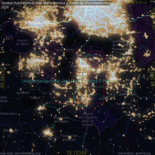
Analysis of Unidad Habitacional José María Morelos y Pavón night lights 2016
Square area 10x10 km:
 3.46%
3.46%90-99
11.47%80-89
16.67%70-79
11.69%60-69
6.93%50-59
2.6%40-49
5.84%30-39
7.14%20-29
15.15%10-19
18.18%0-9
0.87%Square area 50x50 km:
1.43%90-99
3.14%80-89
6.34%70-79
5.97%60-69
5.74%50-59
3.21%40-49
6.3%30-39
5.44%20-29
9.48%10-19
18.38%0-9
34.59%Clear (daylight) street map image can be seen on geolist.org.
Map coordinates:
19° 29' 4.1" North, 99° 57' 55.3" West
18° 49' 13" North, 99° 15' 44" West
18° 9' 12.4" North, 98° 33' 32.8" West
Some cities around Unidad Habitacional José María Morelos y Pavón sort by population:
• Jiutepec
11.2 km =7 mi,  52°
52°
• Temixco
5.3 km =3.3 mi, 47°
• Emiliano Zapata
8.5 km =5.3 mi,  74°
74°
• Xochitepec
5.5 km =3.4 mi,  142°
142°
• Tres de Mayo
7.8 km =4.8 mi, 46°
• Alpuyeca
8.9 km =5.5 mi,  178°
178°
• Chiconcuac
7.1 km =4.4 mi,  125°
125°
• Calera Chica
9.4 km =5.8 mi,  63°
63°
8858154 (p: 10,625)
Sources (retrieved 2019-11-25):
» Earth at Night: Flat Maps 2012, 2016