Xochitepec night lights from space
Night Light of Xochitepec (Morelos) from space (Mexico) Src. Average luminocity for 10x10km area is 69.9525% and for 50x50km: 31.0314%.
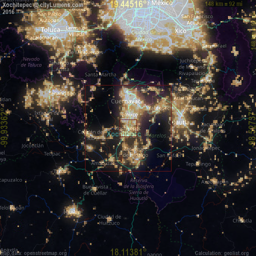
Analysis of Xochitepec night lights 2016
Square area 10x10 km:
 4.13%
4.13%90-99
9.5%80-89
21.28%70-79
22.11%60-69
17.36%50-59
8.06%40-49
8.68%30-39
5.37%20-29
3.51%10-19
0%0-9
0%Square area 50x50 km:
1.41%90-99
3.11%80-89
6.32%70-79
5.93%60-69
5.88%50-59
3.46%40-49
6.81%30-39
5.43%20-29
10.35%10-19
19.38%0-9
31.93%Clear (daylight) street map image can be seen on geolist.org.
Map coordinates:
19° 26' 42.6" North, 99° 56' 1" West
18° 46' 50.9" North, 99° 13' 49.8" West
18° 6' 49.7" North, 98° 31' 38.5" West
Some cities around Xochitepec sort by population:
• Temixco
8 km =5 mi,  3°
3°
• Emiliano Zapata
8.2 km =5.1 mi,  35°
35°
• Tres de Mayo
10 km =6.2 mi,  13°
13°
• Santa Rosa Treinta
10.2 km =6.3 mi,  151°
151°
• Unidad Habitacional José María Morelos y Pavón
5.5 km =3.4 mi,  322°
322°
• Alpuyeca
5.5 km =3.4 mi,  213°
213°
• Chiconcuac
2.5 km =1.6 mi,  84°
84°
• Calera Chica
10 km =6.2 mi,  30°
30°
3514437 (p: 19,164)
Sources (retrieved 2019-11-25):
» Earth at Night: Flat Maps 2012, 2016