Chiconcuac night lights from space
Night Light of Chiconcuac (Morelos) from space (Mexico) Src. Average luminocity for 10x10km area is 67.2624% and for 50x50km: 32.0417%.
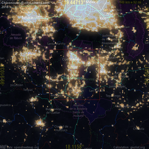
Analysis of Chiconcuac night lights 2016
Square area 10x10 km:
 3.1%
3.1%90-99
8.26%80-89
19.01%70-79
22.52%60-69
17.77%50-59
7.44%40-49
9.5%30-39
6.4%20-29
5.99%10-19
0%0-9
0%Square area 50x50 km:
1.41%90-99
3.21%80-89
6.77%70-79
6.27%60-69
6.13%50-59
3.78%40-49
7.03%30-39
5.49%20-29
10.32%10-19
18.52%0-9
31.07%Clear (daylight) street map image can be seen on geolist.org.
Map coordinates:
19° 26' 49.7" North, 99° 54' 37.3" West
18° 46' 58" North, 99° 12' 26" West
18° 6' 56.9" North, 98° 30' 14.8" West
Some cities around Chiconcuac sort by population:
• Temixco
8 km =5 mi,  346°
346°
• Emiliano Zapata
6.9 km =4.3 mi,  20°
20°
• Xochitepec
2.5 km =1.6 mi,  264°
264°
• Tres de Mayo
9.5 km =5.9 mi,  359°
359°
• Santa Rosa Treinta
9.5 km =5.9 mi,  164°
164°
• Unidad Habitacional José María Morelos y Pavón
7.1 km =4.4 mi,  305°
305°
• Alpuyeca
7.3 km =4.5 mi,  229°
229°
• Calera Chica
8.8 km =5.5 mi, 17°
8858199 (p: 7,071)
Sources (retrieved 2019-11-25):
» Earth at Night: Flat Maps 2012, 2016