Huanímaro night lights from space
Night Light of Huanímaro (Guanajuato) from space (Mexico) Src. Average luminocity for 10x10km area is 14.6591% and for 50x50km: 14.1462%.
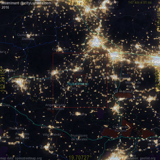
Analysis of Huanímaro night lights 2016
Square area 10x10 km:
 0%
0%90-99
0.38%80-89
3.79%70-79
2.65%60-69
0%50-59
1.52%40-49
2.27%30-39
1.52%20-29
5.49%10-19
10.8%0-9
71.59%Square area 50x50 km:
0.13%90-99
0.47%80-89
2.39%70-79
1.89%60-69
1.77%50-59
1.63%40-49
4.21%30-39
3.61%20-29
4.75%10-19
13.43%0-9
65.72%Clear (daylight) street map image can be seen on geolist.org.
Map coordinates:
21° 1' 32.1" North, 102° 12' 6.6" West
20° 22' 4.2" North, 101° 29' 55.3" West
19° 42' 26.2" North, 100° 47' 44.1" West
Some cities around Huanímaro sort by population:
• Valle de Santiago
32.1 km =19.9 mi,  85°
85°
• Pénjamo
24.4 km =15.2 mi,  286°
286°
• Puruándiro
31.1 km =19.3 mi,  183°
183°
• Abasolo
9.7 km =6 mi,  339°
339°
• Pastor Ortíz
12.3 km =7.6 mi,  235°
235°
• Cerano
31.1 km =19.3 mi,  157°
157°
• San Roque
30.5 km =19 mi,  32°
32°
• Angamacutiro de la Unión
32.8 km =20.4 mi,  222°
222°
4004688 (p: 5,505)
Sources (retrieved 2019-11-25):
» Earth at Night: Flat Maps 2012, 2016