Cerano night lights from space
Night Light of Cerano (Guanajuato) from space (Mexico) Src. Average luminocity for 10x10km area is 8.7024% and for 50x50km: 7.5189%.
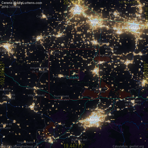
Analysis of Cerano night lights 2016
Square area 10x10 km:
 0%
0%90-99
0%80-89
2.38%70-79
0.79%60-69
1.79%50-59
1.59%40-49
1.39%30-39
0.99%20-29
3.77%10-19
0.4%0-9
86.9%Square area 50x50 km:
0.1%90-99
0.4%80-89
1.44%70-79
0.99%60-69
1.39%50-59
1.07%40-49
1.9%30-39
1.26%20-29
1.6%10-19
3.54%0-9
86.29%Clear (daylight) street map image can be seen on geolist.org.
Map coordinates:
20° 46' 3.5" North, 102° 5' 24.8" West
20° 6' 31.6" North, 101° 23' 13.6" West
19° 26' 49.7" North, 100° 41' 2.3" West
Some cities around Cerano sort by population:
• Uriangato
21.7 km =13.5 mi,  80°
80°
• Moroleón
20.4 km =12.7 mi, 84°
• Puruándiro
13.6 km =8.5 mi,  260°
260°
• Yuriria
28.9 km =18 mi,  66°
66°
• Cuitzeo del Porvenir
29.8 km =18.5 mi,  121°
121°
• Huandacareo
17.5 km =10.9 mi,  138°
138°
• Pastor Ortíz
30.9 km =19.2 mi,  315°
315°
• Huanímaro
31.1 km =19.3 mi,  337°
337°
4014842 (p: 6,530)
Sources (retrieved 2019-11-25):
» Earth at Night: Flat Maps 2012, 2016