San Roque night lights from space
Night Light of San Roque (Guanajuato) from space (Mexico) Src. Average luminocity for 10x10km area is 48.3769% and for 50x50km: 30.6956%.
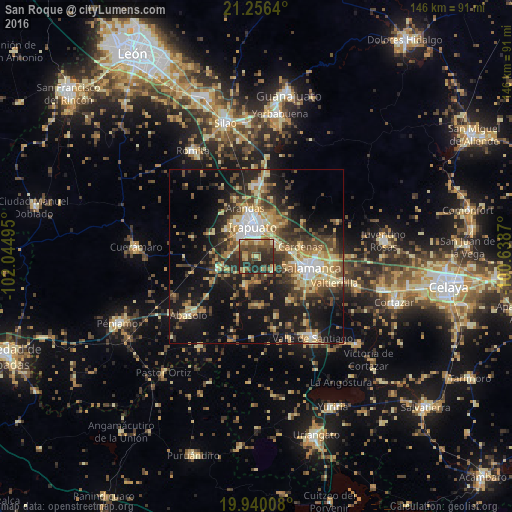
Analysis of San Roque night lights 2016
Square area 10x10 km:
 1.14%
1.14%90-99
2.84%80-89
11.36%70-79
6.82%60-69
9.66%50-59
8.52%40-49
16.86%30-39
11.93%20-29
29.17%10-19
1.7%0-9
0%Square area 50x50 km:
2.55%90-99
2.95%80-89
6%70-79
4.85%60-69
4.15%50-59
4.09%40-49
7.37%30-39
6.85%20-29
9.02%10-19
19.64%0-9
32.54%Clear (daylight) street map image can be seen on geolist.org.
Map coordinates:
21° 15' 23" North, 102° 2' 41.8" West
20° 35' 58.8" North, 101° 20' 30.6" West
19° 56' 24.3" North, 100° 38' 19.3" West
Some cities around San Roque sort by population:
• Irapuato
8.7 km =5.4 mi,  350°
350°
• Salamanca
15.9 km =9.9 mi,  101°
101°
• Abasolo
25.8 km =16 mi,  229°
229°
• Valtierrilla
23.5 km =14.6 mi,  108°
108°
• Arandas
14.3 km =8.9 mi, 346°
• San José Temascatío
13.3 km =8.3 mi,  39°
39°
• Cerro Gordo
22.4 km =13.9 mi,  91°
91°
• Villas de Irapuato
11.8 km =7.3 mi,  325°
325°
4024289 (p: 5,563)
Sources (retrieved 2019-11-25):
» Earth at Night: Flat Maps 2012, 2016