Pastor Ortíz night lights from space
Night Light of Pastor Ortíz (Michoacán) from space (Mexico) Src. Average luminocity for 10x10km area is 12.6825% and for 50x50km: 10.3663%.
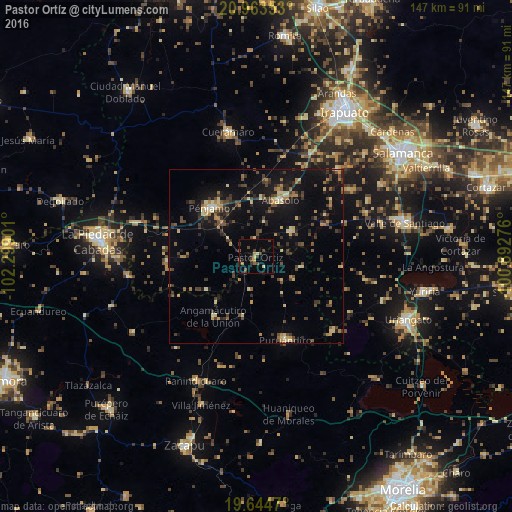
Analysis of Pastor Ortíz night lights 2016
Square area 10x10 km:
 0%
0%90-99
0%80-89
2.78%70-79
1.39%60-69
0.6%50-59
1.19%40-49
5.95%30-39
4.37%20-29
1.59%10-19
0.79%0-9
81.35%Square area 50x50 km:
0.13%90-99
0.47%80-89
1.81%70-79
1.15%60-69
1.27%50-59
1.18%40-49
3.17%30-39
2.65%20-29
2.28%10-19
8.24%0-9
77.65%Clear (daylight) street map image can be seen on geolist.org.
Map coordinates:
20° 57' 48.7" North, 102° 17' 56.4" West
20° 18' 19.9" North, 101° 35' 45.2" West
19° 38' 40.9" North, 100° 53' 33.9" West
Some cities around Pastor Ortíz sort by population:
• Pénjamo
19.2 km =11.9 mi,  316°
316°
• Puruándiro
25.5 km =15.8 mi,  160°
160°
• Abasolo
17.4 km =10.8 mi,  22°
22°
• Cuerámaro
36.5 km =22.7 mi,  347°
347°
• Cerano
30.9 km =19.2 mi,  135°
135°
• Panindícuaro
39.6 km =24.6 mi,  205°
205°
• Huanímaro
12.3 km =7.6 mi,  55°
55°
• Angamacutiro de la Unión
21.1 km =13.1 mi, 214°
4023964 (p: 6,630)
Sources (retrieved 2019-11-25):
» Earth at Night: Flat Maps 2012, 2016