Pénjamo night lights from space
Night Light of Pénjamo (Guanajuato) from space (Mexico) Src. Average luminocity for 10x10km area is 34.0682% and for 50x50km: 10.1235%.

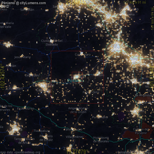
Analysis of Pénjamo night lights 2016
Square area 10x10 km:
 2.46%
2.46%90-99
3.79%80-89
6.44%70-79
5.3%60-69
4.55%50-59
2.84%40-49
7.2%30-39
10.23%20-29
7.01%10-19
35.98%0-9
14.2%Square area 50x50 km:
0.14%90-99
0.45%80-89
1.66%70-79
1.16%60-69
1.21%50-59
1.25%40-49
3.13%30-39
2.43%20-29
1.99%10-19
8.92%0-9
77.65%Clear (daylight) street map image can be seen on geolist.org.
Map coordinates:
21° 5' 18.8" North, 102° 25' 32.7" West
20° 25' 51.9" North, 101° 43' 21.4" West
19° 46' 14.8" North, 101° 1' 10.2" West
Some cities around Pénjamo sort by population:
• La Piedad
33.6 km =20.9 mi,  252°
252°
• Abasolo
20.1 km =12.5 mi,  84°
84°
• Ciudad Manuel Doblado
40.8 km =25.4 mi,  324°
324°
• Cuerámaro
22.2 km =13.8 mi,  13°
13°
• Santa Ana Pacueco
32 km =19.9 mi, 253°
• Pastor Ortíz
19.2 km =11.9 mi,  136°
136°
• Huanímaro
24.4 km =15.2 mi,  106°
106°
• Angamacutiro de la Unión
31.3 km =19.4 mi,  177°
177°
3992986 (p: 40,070)
Sources (retrieved 2019-11-25):
» Earth at Night: Flat Maps 2012, 2016