Angamacutiro de la Unión night lights from space
Night Light of Angamacutiro de la Unión (Michoacán) from space (Mexico) Src. Average luminocity for 10x10km area is 6.7758% and for 50x50km: 5.8265%.
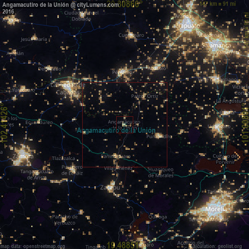
Analysis of Angamacutiro de la Unión night lights 2016
Square area 10x10 km:
 0%
0%90-99
0.6%80-89
2.18%70-79
1.19%60-69
0%50-59
0.79%40-49
0.6%30-39
2.98%20-29
1.79%10-19
0.2%0-9
89.68%Square area 50x50 km:
0%90-99
0.21%80-89
1.03%70-79
0.78%60-69
0.75%50-59
0.77%40-49
1.92%30-39
1.35%20-29
1.02%10-19
1.31%0-9
90.87%Clear (daylight) street map image can be seen on geolist.org.
Map coordinates:
20° 48' 31.2" North, 102° 24' 51.3" West
20° 8' 59.9" North, 101° 42' 40.1" West
19° 29' 18.6" North, 101° 0' 28.8" West
Some cities around Angamacutiro de la Unión sort by population:
• Zacapu
37.4 km =23.2 mi,  192°
192°
• Pénjamo
31.3 km =19.4 mi,  357°
357°
• Puruándiro
21.5 km =13.4 mi,  108°
108°
• Abasolo
38.3 km =23.8 mi,  29°
29°
• Pastor Ortíz
21.1 km =13.1 mi, 34°
• Cerano
34.1 km =21.2 mi,  97°
97°
• Panindícuaro
19 km =11.8 mi,  195°
195°
• Huanímaro
32.8 km =20.4 mi,  42°
42°
4018518 (p: 5,030)
Sources (retrieved 2019-11-25):
» Earth at Night: Flat Maps 2012, 2016