San Bartolo Cuautlalpan night lights from space
Night Light of San Bartolo Cuautlalpan (México) from space (Mexico) Src. Average luminocity for 10x10km area is 75.3037% and for 50x50km: 56.1512%.
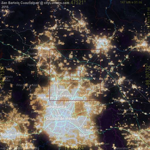
Analysis of San Bartolo Cuautlalpan night lights 2016
Square area 10x10 km:
 13.22%
90-99
20.45%80-89
10.54%70-79
15.08%60-69
20.45%50-59
5.17%40-49
5.58%30-39
8.06%20-29
1.45%10-19
0%0-9
0%Square area 50x50 km:
12.17%90-99
9.87%80-89
10.1%70-79
10.32%60-69
10.04%50-59
6.07%40-49
5.95%30-39
4.57%20-29
7.68%10-19
12.56%0-9
10.67%Clear (daylight) street map image can be seen on geolist.org.
Map coordinates:
20° 28' 30.8" North, 99° 42' 48.9" West
19° 48' 54.4" North, 99° 0' 37.6" West
19° 9' 8.1" North, 98° 18' 26.4" West
Some cities around San Bartolo Cuautlalpan sort by population:
• Tizayuca
4.4 km =2.7 mi,  55°
55°
• Reyes Acozac
5.4 km =3.4 mi,  144°
144°
• Santa María Ajoloapan
7.9 km =4.9 mi, 136°
• Fraccionamiento la Trinidad
7.7 km =4.8 mi,  281°
281°
• Paseos de San Juan
3.8 km =2.4 mi,  191°
191°
• San Sebastián
5.8 km =3.6 mi,  234°
234°
• Arbolada los Sauces
3.5 km =2.2 mi,  271°
271°
• Huitzila
5.7 km =3.5 mi,  94°
94°
3519644 (p: 10,989)
Sources (retrieved 2019-11-25):
» Earth at Night: Flat Maps 2012, 2016