San Francisco Zacacalco night lights from space
Night Light of San Francisco Zacacalco (Morelos) from space (Mexico) Src. Average luminocity for 10x10km area is 23.987% and for 50x50km: 40.3905%.
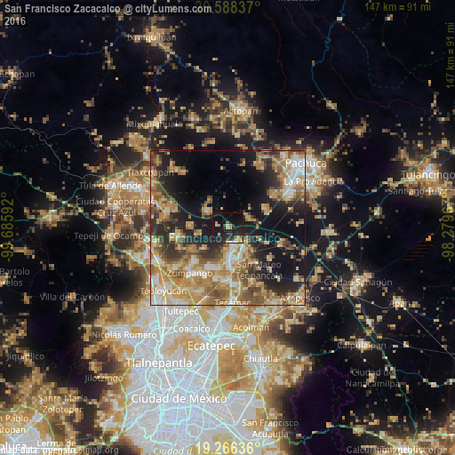
Analysis of San Francisco Zacacalco night lights 2016
Square area 10x10 km:
 0.22%
0.22%90-99
1.95%80-89
2.6%70-79
5.41%60-69
2.81%50-59
1.08%40-49
2.6%30-39
3.03%20-29
16.88%10-19
39.61%0-9
23.81%Square area 50x50 km:
3.8%90-99
5.16%80-89
7.35%70-79
8.25%60-69
9.68%50-59
5.4%40-49
6.18%30-39
5.3%20-29
9.28%10-19
16.85%0-9
22.76%Clear (daylight) street map image can be seen on geolist.org.
Map coordinates:
20° 35' 18.1" North, 99° 41' 9.3" West
19° 55' 43.5" North, 98° 58' 58" West
19° 15' 58.9" North, 98° 16' 46.8" West
Some cities around San Francisco Zacacalco sort by population:
• Tizayuca
10.2 km =6.3 mi,  176°
176°
• Don Antonio
7.9 km =4.9 mi,  140°
140°
• San Bartolo Cuautlalpan
13 km =8.1 mi,  192°
192°
• Santa María Ajoloapan
8.4 km =5.2 mi,  309°
309°
• Jilotzingo
10.6 km =6.6 mi,  231°
231°
• Tolcayuca
7.4 km =4.6 mi,  63°
63°
• Tlapanaloya
11.9 km =7.4 mi,  273°
273°
• Huitzila
13.4 km =8.3 mi,  167°
167°
3519243 (p: 7,420)
Sources (retrieved 2019-11-25):
» Earth at Night: Flat Maps 2012, 2016