Amacuzac night lights from space
Night Light of Amacuzac (Morelos) from space (Mexico) Src. Average luminocity for 10x10km area is 18.876% and for 50x50km: 16.9469%.
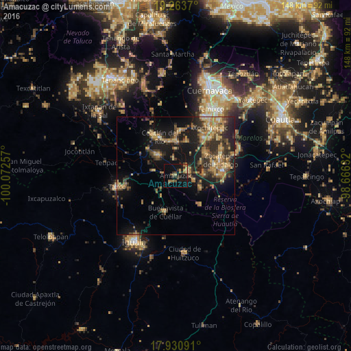
Analysis of Amacuzac night lights 2016
Square area 10x10 km:
 0%
0%90-99
0%80-89
2.89%70-79
2.07%60-69
5.99%50-59
1.86%40-49
4.34%30-39
3.93%20-29
3.51%10-19
22.73%0-9
52.69%Square area 50x50 km:
0.26%90-99
0.63%80-89
2.96%70-79
3.31%60-69
3.96%50-59
2.4%40-49
3.43%30-39
3.9%20-29
5.6%10-19
13.61%0-9
59.95%Clear (daylight) street map image can be seen on geolist.org.
Map coordinates:
19° 15' 49.3" North, 100° 4' 21.3" West
18° 35' 55" North, 99° 22' 10" West
17° 55' 51.3" North, 98° 39' 58.8" West
Some cities around Amacuzac sort by population:
• Puente de Ixtla
5.7 km =3.5 mi,  71°
71°
• Xoxocotla
16.1 km =10 mi,  53°
53°
• La Joya
12.7 km =7.9 mi,  306°
306°
• Galeana
17.1 km =10.6 mi,  75°
75°
• Coatetelco
15.3 km =9.5 mi,  17°
17°
• Buenavista de Cuéllar
16 km =9.9 mi,  194°
194°
• Tehuixtla
11.2 km =7 mi,  112°
112°
• Tlamacazapa
17.9 km =11.1 mi,  230°
230°
3532951 (p: 5,368)
Sources (retrieved 2019-11-25):
» Earth at Night: Flat Maps 2012, 2016