Qaryat Sulūq night lights from space
Night Light of Qaryat Sulūq (Banghāzī) from space (Libya) Src. Average luminocity for 10x10km area is 28.3333% and for 50x50km: 4.7323%.
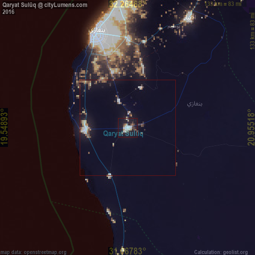
Analysis of Qaryat Sulūq night lights 2016
Square area 10x10 km:
 5.13%
5.13%90-99
7.33%80-89
1.83%70-79
1.83%60-69
1.1%50-59
1.65%40-49
4.03%30-39
5.49%20-29
3.85%10-19
38.83%0-9
28.94%Square area 50x50 km:
0.62%90-99
0.8%80-89
0.44%70-79
0.29%60-69
0.4%50-59
0.49%40-49
0.84%30-39
0.84%20-29
0.79%10-19
4.32%0-9
90.17%Clear (daylight) street map image can be seen on geolist.org.
Map coordinates:
32° 15' 52.8" North, 19° 32' 56.1" East
31° 40' 5.4" North, 20° 15' 7.4" East
31° 4' 4.2" North, 20° 57' 18.6" East
Some cities around Qaryat Sulūq sort by population:
• Benghazi
52.6 km =32.7 mi,  340°
340°
• Ajdabiya
101.5 km =63.1 mi,  181°
181°
• Al Marj
106.6 km =66.2 mi,  30°
30°
• Al Bayḑā’
186.6 km =115.9 mi,  49°
49°
• Al Abyār
66.5 km =41.3 mi, 29°
• Tūkrah
101.1 km =62.8 mi,  17°
17°
• Az Zuwaytīnah
80.6 km =50.1 mi,  188°
188°
• Al Burayqah
154.5 km =96 mi,  204°
204°
81604 (p: 15,543)
Sources (retrieved 2019-11-25):
» Earth at Night: Flat Maps 2012, 2016