Zanica night lights from space
Night Light of Zanica (Lombardy) from space (Italy) Src. Average luminocity for 10x10km area is 80.803% and for 50x50km: 51.8164%.
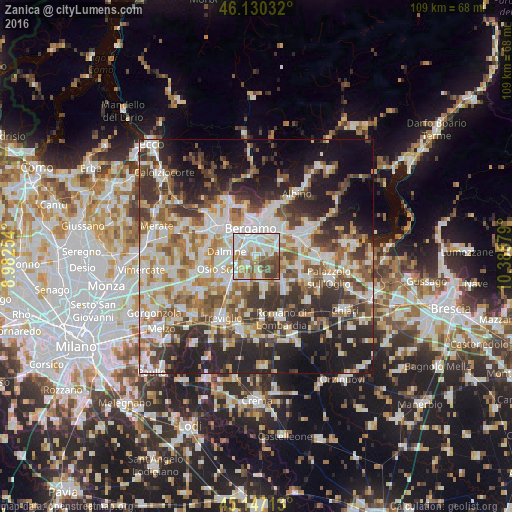
Analysis of Zanica night lights 2016
Square area 10x10 km:
 27.73%
90-99
23.64%80-89
6.82%70-79
9.24%60-69
12.27%50-59
7.42%40-49
8.33%30-39
4.55%20-29
0%10-19
0%0-9
0%Square area 50x50 km:
10.98%90-99
11.99%80-89
4.97%70-79
6.01%60-69
7.2%50-59
7.81%40-49
7.19%30-39
8.71%20-29
12.43%10-19
13.92%0-9
8.77%Clear (daylight) street map image can be seen on geolist.org.
Map coordinates:
46° 7' 49.2" North, 8° 58' 57.1" East
45° 38' 27.2" North, 9° 41' 8.4" East
45° 8' 49.7" North, 10° 23' 19.6" East
Some cities around Zanica sort by population:
• Bergamo
6.3 km =3.9 mi,  346°
346°
• Seriate
5.8 km =3.6 mi,  31°
31°
• Dalmine
6.2 km =3.9 mi,  278°
278°
• Stezzano
2.8 km =1.7 mi,  290°
290°
• Urgnano
4.7 km =2.9 mi,  171°
171°
• Verdello
6.1 km =3.8 mi,  227°
227°
• Azzano San Paolo
2.1 km =1.3 mi,  332°
332°
• Grassobbio
3.6 km =2.2 mi,  60°
60°
3163911 (p: 7,242)
Sources (retrieved 2019-11-25):
» Earth at Night: Flat Maps 2012, 2016