Urgnano night lights from space
Night Light of Urgnano (Lombardy) from space (Italy) Src. Average luminocity for 10x10km area is 63.1697% and for 50x50km: 53.0653%.
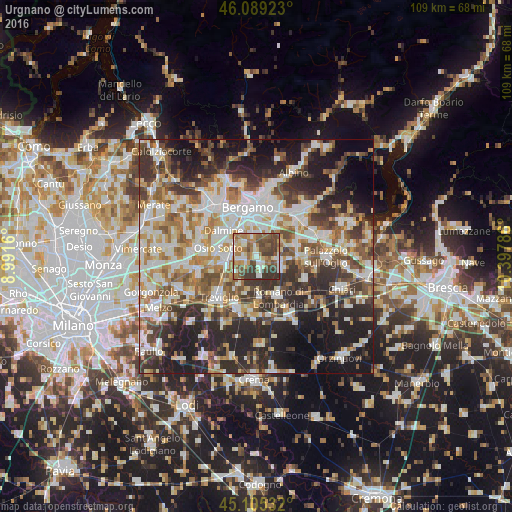
Analysis of Urgnano night lights 2016
Square area 10x10 km:
 10%
10%90-99
12.27%80-89
5.3%70-79
7.88%60-69
15.61%50-59
13.03%40-49
15.76%30-39
17.12%20-29
3.03%10-19
0%0-9
0%Square area 50x50 km:
11.01%90-99
12.15%80-89
5.13%70-79
6.12%60-69
7.48%50-59
8.13%40-49
7.31%30-39
9.02%20-29
13.91%10-19
14.98%0-9
4.76%Clear (daylight) street map image can be seen on geolist.org.
Map coordinates:
46° 5' 21.2" North, 8° 59' 29.8" East
45° 35' 57.9" North, 9° 41' 41" East
45° 6' 19.2" North, 10° 23' 52.3" East
Some cities around Urgnano sort by population:
• Stezzano
6.5 km =4 mi,  329°
329°
• Cologno al Serio
2.8 km =1.7 mi,  156°
156°
• Martinengo
6.4 km =4 mi,  118°
118°
• Verdellino
6.7 km =4.2 mi,  271°
271°
• Verdello
5.2 km =3.2 mi,  275°
275°
• Zanica
4.7 km =2.9 mi,  351°
351°
• Ghisalba
4.9 km =3 mi,  97°
97°
• Spirano
2.9 km =1.8 mi,  225°
225°
3165031 (p: 7,914)
Sources (retrieved 2019-11-25):
» Earth at Night: Flat Maps 2012, 2016