Stezzano night lights from space
Night Light of Stezzano (Lombardy) from space (Italy) Src. Average luminocity for 10x10km area is 88.6515% and for 50x50km: 53.43%.
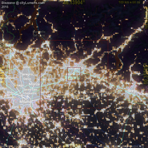
Analysis of Stezzano night lights 2016
Square area 10x10 km:
 37.88%
90-99
27.88%80-89
8.79%70-79
7.73%60-69
10.76%50-59
3.79%40-49
3.03%30-39
0.15%20-29
0%10-19
0%0-9
0%Square area 50x50 km:
11.68%90-99
12.64%80-89
5.07%70-79
6.18%60-69
7.66%50-59
7.86%40-49
7.47%30-39
8.73%20-29
11.65%10-19
12.99%0-9
8.06%Clear (daylight) street map image can be seen on geolist.org.
Map coordinates:
46° 8' 20.5" North, 8° 56' 55.6" East
45° 38' 58.8" North, 9° 39' 6.9" East
45° 9' 21.6" North, 10° 21' 18.2" East
Some cities around Stezzano sort by population:
• Bergamo
5.3 km =3.3 mi,  12°
12°
• Dalmine
3.6 km =2.2 mi,  269°
269°
• Treviolo
4.1 km =2.5 mi,  310°
310°
• Curno
5.5 km =3.4 mi,  322°
322°
• Verdello
5.4 km =3.4 mi,  199°
199°
• Zanica
2.8 km =1.7 mi,  110°
110°
• Azzano San Paolo
1.9 km =1.2 mi,  60°
60°
• Grassobbio
5.8 km =3.6 mi,  82°
82°
3166151 (p: 12,316)
Sources (retrieved 2019-11-25):
» Earth at Night: Flat Maps 2012, 2016