Grassobbio night lights from space
Night Light of Grassobbio (Lombardy) from space (Italy) Src. Average luminocity for 10x10km area is 80.7652% and for 50x50km: 49.0418%.
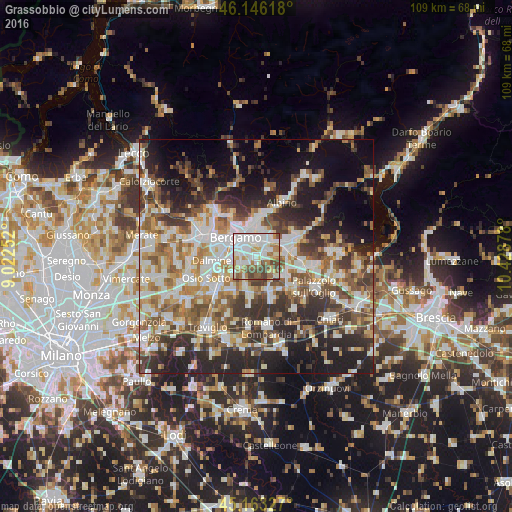
Analysis of Grassobbio night lights 2016
Square area 10x10 km:
 29.39%
90-99
21.82%80-89
7.58%70-79
8.79%60-69
10.61%50-59
8.18%40-49
11.21%30-39
2.42%20-29
0%10-19
0%0-9
0%Square area 50x50 km:
9.88%90-99
10.86%80-89
4.74%70-79
5.57%60-69
7.04%50-59
7.87%40-49
7.3%30-39
8.24%20-29
12.34%10-19
14.17%0-9
11.97%Clear (daylight) street map image can be seen on geolist.org.
Map coordinates:
46° 8' 46.2" North, 9° 1' 21.1" East
45° 39' 24.8" North, 9° 43' 32.3" East
45° 9' 47.8" North, 10° 25' 43.6" East
Some cities around Grassobbio sort by population:
• Seriate
3.2 km =2 mi,  358°
358°
• Stezzano
5.8 km =3.6 mi,  262°
262°
• Albano Sant'Alessandro
4.7 km =2.9 mi,  42°
42°
• Zanica
3.6 km =2.2 mi,  240°
240°
• Azzano San Paolo
4.1 km =2.5 mi,  271°
271°
• Gorle
5 km =3.1 mi,  349°
349°
• Pedrengo
4.4 km =2.7 mi,  9°
9°
• Brusaporto
3.1 km =1.9 mi,  59°
59°
6535170 (p: 5,922)
Sources (retrieved 2019-11-25):
» Earth at Night: Flat Maps 2012, 2016