Azzano San Paolo night lights from space
Night Light of Azzano San Paolo (Lombardy) from space (Italy) Src. Average luminocity for 10x10km area is 87.4833% and for 50x50km: 51.762%.
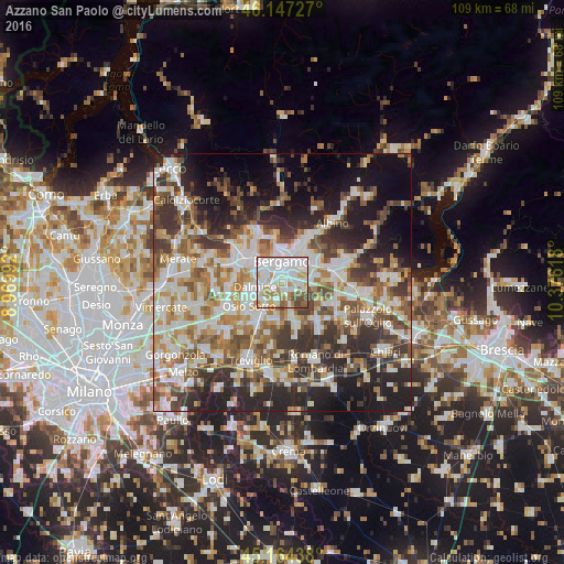
Analysis of Azzano San Paolo night lights 2016
Square area 10x10 km:
 36.52%
90-99
28.18%80-89
6.67%70-79
8.94%60-69
8.48%50-59
6.06%40-49
5%30-39
0.15%20-29
0%10-19
0%0-9
0%Square area 50x50 km:
11%90-99
11.94%80-89
4.91%70-79
6.08%60-69
7.43%50-59
7.83%40-49
7.5%30-39
8.72%20-29
11.62%10-19
13.11%0-9
9.85%Clear (daylight) street map image can be seen on geolist.org.
Map coordinates:
46° 8' 50.2" North, 8° 58' 11.7" East
45° 39' 28.7" North, 9° 40' 23" East
45° 9' 51.8" North, 10° 22' 34.2" East
Some cities around Azzano San Paolo sort by population:
• Bergamo
4.3 km =2.7 mi,  353°
353°
• Seriate
5 km =3.1 mi,  52°
52°
• Dalmine
5.3 km =3.3 mi,  259°
259°
• Stezzano
1.9 km =1.2 mi,  240°
240°
• Treviolo
5.1 km =3.2 mi,  290°
290°
• Zanica
2.1 km =1.3 mi,  152°
152°
• Gorle
5.8 km =3.6 mi,  33°
33°
• Grassobbio
4.1 km =2.5 mi,  91°
91°
6535157 (p: 7,131)
Sources (retrieved 2019-11-25):
» Earth at Night: Flat Maps 2012, 2016