Nogara night lights from space
Night Light of Nogara (Veneto) from space (Italy) Src. Average luminocity for 10x10km area is 31.8424% and for 50x50km: 31.7769%.
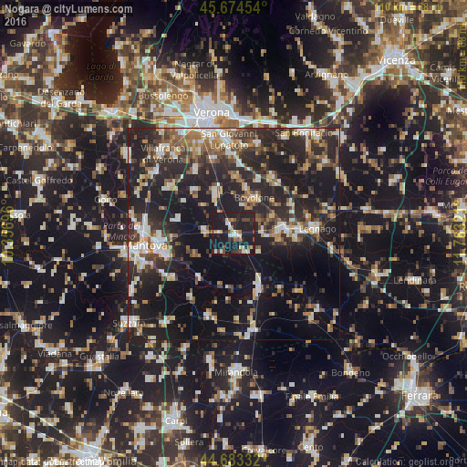
Analysis of Nogara night lights 2016
Square area 10x10 km:
 3.18%
3.18%90-99
4.39%80-89
4.55%70-79
2.73%60-69
2.58%50-59
3.18%40-49
5%30-39
2.73%20-29
13.18%10-19
56.52%0-9
1.97%Square area 50x50 km:
3.62%90-99
5.47%80-89
3.18%70-79
3.07%60-69
3.54%50-59
4.84%40-49
4.94%30-39
5.43%20-29
15.54%10-19
27.92%0-9
22.45%Clear (daylight) street map image can be seen on geolist.org.
Map coordinates:
45° 40' 28.3" North, 10° 21' 25.1" East
45° 10' 51.9" North, 11° 3' 36.3" East
44° 40' 60" North, 11° 45' 47.6" East
Some cities around Nogara sort by population:
• Legnago
19 km =11.8 mi,  85°
85°
• Bovolone
10 km =6.2 mi,  26°
26°
• Cerea
12.3 km =7.6 mi, 85°
• Isola della Scala
10.6 km =6.6 mi,  337°
337°
• Mottella
17 km =10.6 mi,  263°
263°
• Vigasio
17.7 km =11 mi,  329°
329°
• Ostiglia
13.7 km =8.5 mi,  154°
154°
• San Benedetto Po
18 km =11.2 mi,  213°
213°
3172235 (p: 7,003)
Sources (retrieved 2019-11-25):
» Earth at Night: Flat Maps 2012, 2016