Ostiglia night lights from space
Night Light of Ostiglia (Lombardy) from space (Italy) Src. Average luminocity for 10x10km area is 21.5864% and for 50x50km: 23.4121%.
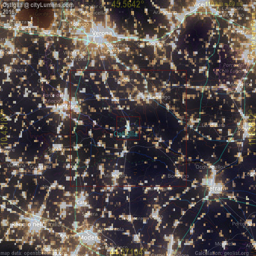
Analysis of Ostiglia night lights 2016
Square area 10x10 km:
 1.97%
1.97%90-99
6.21%80-89
1.36%70-79
1.67%60-69
0.61%50-59
1.36%40-49
2.12%30-39
1.52%20-29
3.94%10-19
43.48%0-9
35.76%Square area 50x50 km:
2.07%90-99
3.61%80-89
2.5%70-79
2.04%60-69
2.13%50-59
2.84%40-49
3.72%30-39
3.49%20-29
8.94%10-19
32.84%0-9
35.82%Clear (daylight) street map image can be seen on geolist.org.
Map coordinates:
45° 33' 51.1" North, 10° 25' 54.7" East
45° 4' 11.2" North, 11° 8' 6" East
44° 34' 15.7" North, 11° 50' 17.2" East
Some cities around Ostiglia sort by population:
• Legnago
19 km =11.8 mi,  43°
43°
• Mirandola
21.2 km =13.2 mi,  194°
194°
• Bovolone
21.4 km =13.3 mi,  356°
356°
• Cerea
14.8 km =9.2 mi,  25°
25°
• Isola della Scala
24.3 km =15.1 mi,  335°
335°
• Nogara
13.7 km =8.5 mi,  334°
334°
• Poggio Rusco
11.7 km =7.3 mi, 191°
• San Benedetto Po
16 km =9.9 mi,  260°
260°
3171792 (p: 5,648)
Sources (retrieved 2019-11-25):
» Earth at Night: Flat Maps 2012, 2016