Mottella night lights from space
Night Light of Mottella (Lombardy) from space (Italy) Src. Average luminocity for 10x10km area is 57.0136% and for 50x50km: 29.7896%.
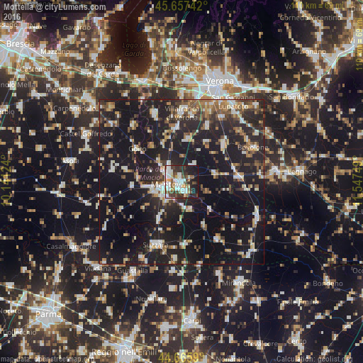
Analysis of Mottella night lights 2016
Square area 10x10 km:
 12.88%
90-99
18.03%80-89
3.64%70-79
4.85%60-69
3.33%50-59
7.88%40-49
8.33%30-39
11.82%20-29
14.55%10-19
14.55%0-9
0.15%Square area 50x50 km:
3.07%90-99
5.38%80-89
2.68%70-79
2.87%60-69
3.11%50-59
4.17%40-49
4.2%30-39
4.59%20-29
12.63%10-19
36.87%0-9
20.44%Clear (daylight) street map image can be seen on geolist.org.
Map coordinates:
45° 39' 26.7" North, 10° 8' 28.5" East
45° 9' 49.8" North, 10° 50' 39.7" East
44° 39' 57.2" North, 11° 32' 51" East
Some cities around Mottella sort by population:
• Mantova
3.7 km =2.3 mi,  263°
263°
• Sant'Antonio
5.4 km =3.4 mi,  312°
312°
• Cerese
6.7 km =4.2 mi,  220°
220°
• Nogara
17 km =10.6 mi,  83°
83°
• Goito
17.3 km =10.7 mi,  303°
303°
• San Benedetto Po
14.8 km =9.2 mi,  151°
151°
• Marmirolo
9.3 km =5.8 mi, 311°
• Eremo
8.8 km =5.5 mi,  245°
245°
6534565 (p: 8,019)
Sources (retrieved 2019-11-25):
» Earth at Night: Flat Maps 2012, 2016