Vigasio night lights from space
Night Light of Vigasio (Veneto) from space (Italy) Src. Average luminocity for 10x10km area is 41.2937% and for 50x50km: 40.1372%.
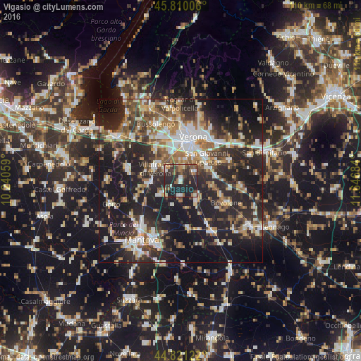
Analysis of Vigasio night lights 2016
Square area 10x10 km:
 3.81%
3.81%90-99
6.35%80-89
3.49%70-79
3.02%60-69
5.56%50-59
10%40-49
6.03%30-39
11.27%20-29
31.27%10-19
19.21%0-9
0%Square area 50x50 km:
6%90-99
7.58%80-89
3.91%70-79
3.99%60-69
5.48%50-59
6.38%40-49
6.05%30-39
6.64%20-29
17.49%10-19
26.87%0-9
9.62%Clear (daylight) street map image can be seen on geolist.org.
Map coordinates:
45° 48' 36.2" North, 10° 14' 26.1" East
45° 19' 4.1" North, 10° 56' 37.4" East
44° 49' 16.4" North, 11° 38' 48.6" East
Some cities around Vigasio sort by population:
• Verona
12.9 km =8 mi,  14°
14°
• San Giovanni Lupatoto
10.6 km =6.6 mi,  47°
47°
• Villafranca di Verona
8.7 km =5.4 mi,  297°
297°
• Beccacivetta-Azzano
6.4 km =4 mi, 12°
• Isola della Scala
7.4 km =4.6 mi,  136°
136°
• Sommacampagna
12.5 km =7.8 mi,  321°
321°
• Povegliano Veronese
5.9 km =3.7 mi, 303°
• Dossobuono
8.8 km =5.5 mi,  342°
342°
3164381 (p: 6,918)
Sources (retrieved 2019-11-25):
» Earth at Night: Flat Maps 2012, 2016