Lavis night lights from space
Night Light of Lavis (Trentino-Alto Adige) from space (Italy) Src. Average luminocity for 10x10km area is 37.8224% and for 50x50km: 9.6897%.
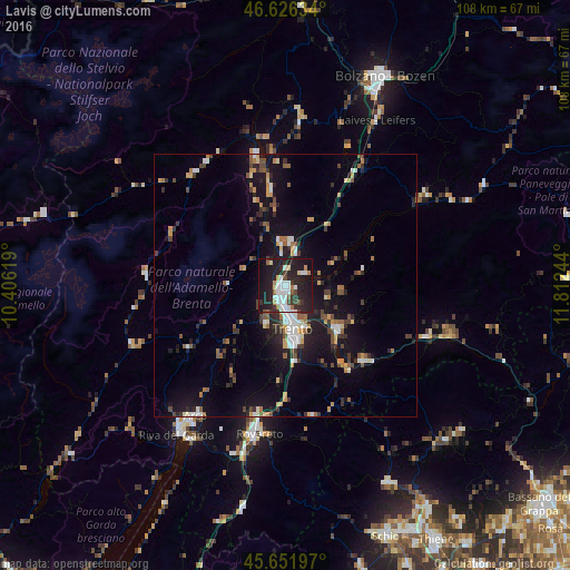
Analysis of Lavis night lights 2016
Square area 10x10 km:
 7.95%
7.95%90-99
9.23%80-89
1.99%70-79
2.13%60-69
2.84%50-59
2.41%40-49
3.55%30-39
5.82%20-29
23.15%10-19
34.09%0-9
6.82%Square area 50x50 km:
1.08%90-99
1.45%80-89
0.69%70-79
1.14%60-69
1.1%50-59
1.26%40-49
1.38%30-39
1.57%20-29
3%10-19
9.19%0-9
78.14%Clear (daylight) street map image can be seen on geolist.org.
Map coordinates:
46° 37' 34.8" North, 10° 24' 22.3" East
46° 8' 28.7" North, 11° 6' 33.5" East
45° 39' 7.1" North, 11° 48' 44.8" East
Some cities around Lavis sort by population:
• Trento
8.2 km =5.1 mi,  173°
173°
• Rovereto
28.4 km =17.6 mi,  190°
190°
• Pergine Valsugana
13.1 km =8.1 mi,  130°
130°
• Mezzolombardo
7.5 km =4.7 mi,  352°
352°
• Borgo Valsugana
28.7 km =17.8 mi,  110°
110°
• Levico Terme
20.8 km =12.9 mi, 133°
• Cles
25.3 km =15.7 mi, 346°
• Mattarello
14.8 km =9.2 mi, 173°
3174984 (p: 6,404)
Sources (retrieved 2019-11-25):
» Earth at Night: Flat Maps 2012, 2016