Borgo Valsugana night lights from space
Night Light of Borgo Valsugana (Trentino-Alto Adige) from space (Italy) Src. Average luminocity for 10x10km area is 11.7784% and for 50x50km: 5.3311%.
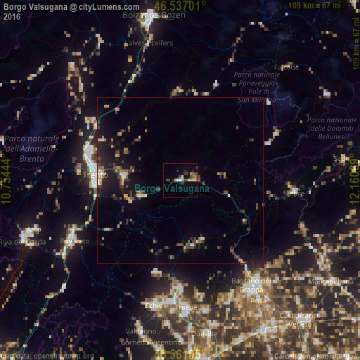
Analysis of Borgo Valsugana night lights 2016
Square area 10x10 km:
 0.71%
0.71%90-99
0.57%80-89
2.84%70-79
0.99%60-69
1.85%50-59
0.99%40-49
2.41%30-39
3.55%20-29
2.56%10-19
3.41%0-9
80.11%Square area 50x50 km:
0.3%90-99
0.55%80-89
0.45%70-79
0.55%60-69
0.65%50-59
0.59%40-49
1.28%30-39
1.13%20-29
1.73%10-19
4.82%0-9
87.95%Clear (daylight) street map image can be seen on geolist.org.
Map coordinates:
46° 32' 13.2" North, 10° 45' 16" East
46° 3' 4.3" North, 11° 27' 27.2" East
45° 33' 39.8" North, 12° 9' 38.5" East
Some cities around Borgo Valsugana sort by population:
• Trento
26 km =16.2 mi,  274°
274°
• Feltre
34.3 km =21.3 mi,  95°
95°
• Pergine Valsugana
17 km =10.6 mi, 274°
• Piovene Rocchette
32.9 km =20.4 mi,  183°
183°
• Mezzolombardo
32.8 km =20.4 mi,  302°
302°
• Lavis
28.7 km =17.8 mi,  290°
290°
• Levico Terme
12.6 km =7.8 mi,  249°
249°
• Mattarello
25.7 km =16 mi,  259°
259°
3181822 (p: 6,587)
Sources (retrieved 2019-11-25):
» Earth at Night: Flat Maps 2012, 2016