Mattarello night lights from space
Night Light of Mattarello (Trentino-Alto Adige) from space (Italy) Src. Average luminocity for 10x10km area is 20.5795% and for 50x50km: 10.6648%.
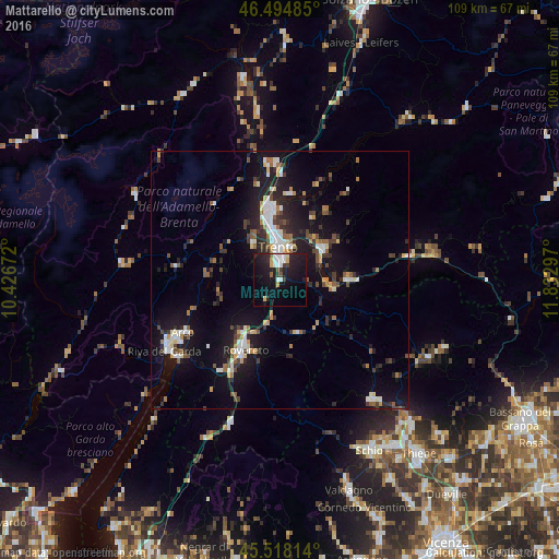
Analysis of Mattarello night lights 2016
Square area 10x10 km:
 4.12%
4.12%90-99
3.69%80-89
1.42%70-79
1.14%60-69
0.43%50-59
0.57%40-49
2.41%30-39
2.27%20-29
9.23%10-19
29.55%0-9
45.17%Square area 50x50 km:
1.41%90-99
1.88%80-89
0.75%70-79
0.96%60-69
1.07%50-59
1.28%40-49
1.35%30-39
1.66%20-29
3.12%10-19
10.75%0-9
75.78%Clear (daylight) street map image can be seen on geolist.org.
Map coordinates:
46° 29' 41.5" North, 10° 25' 36.2" East
46° 0' 31.1" North, 11° 7' 47.4" East
45° 31' 5.3" North, 11° 49' 58.7" East
Some cities around Mattarello sort by population:
• Trento
6.6 km =4.1 mi,  354°
354°
• Rovereto
14.9 km =9.3 mi,  207°
207°
• Arco
21.3 km =13.2 mi,  241°
241°
• Pergine Valsugana
10.4 km =6.5 mi,  53°
53°
• Mori
20.9 km =13 mi, 213°
• Mezzolombardo
22.3 km =13.9 mi, 353°
• Lavis
14.8 km =9.2 mi, 353°
• Levico Terme
13.5 km =8.4 mi,  88°
88°
3173704 (p: 5,214)
Sources (retrieved 2019-11-25):
» Earth at Night: Flat Maps 2012, 2016