Levico Terme night lights from space
Night Light of Levico Terme (Trentino-Alto Adige) from space (Italy) Src. Average luminocity for 10x10km area is 13.9474% and for 50x50km: 9.8853%.
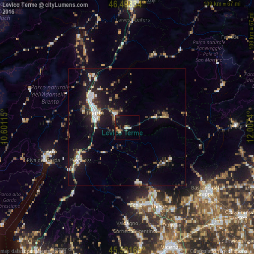
Analysis of Levico Terme night lights 2016
Square area 10x10 km:
 0.85%
0.85%90-99
2.13%80-89
1.28%70-79
1.7%60-69
1.14%50-59
2.13%40-49
2.41%30-39
3.13%20-29
1.42%10-19
15.63%0-9
68.18%Square area 50x50 km:
1.22%90-99
1.61%80-89
0.72%70-79
0.95%60-69
1.03%50-59
1.08%40-49
1.56%30-39
1.75%20-29
3.04%10-19
9.16%0-9
77.88%Clear (daylight) street map image can be seen on geolist.org.
Map coordinates:
46° 29' 54" North, 10° 36' 4.1" East
46° 0' 43.8" North, 11° 18' 15.4" East
45° 31' 18.1" North, 12° 0' 26.6" East
Some cities around Levico Terme sort by population:
• Trento
15.4 km =9.6 mi,  293°
293°
• Rovereto
24.5 km =15.2 mi,  236°
236°
• Pergine Valsugana
7.8 km =4.8 mi,  318°
318°
• Piovene Rocchette
30.2 km =18.8 mi,  160°
160°
• Mezzolombardo
27 km =16.8 mi, 323°
• Borgo Valsugana
12.6 km =7.8 mi,  69°
69°
• Lavis
20.8 km =12.9 mi,  313°
313°
• Mattarello
13.5 km =8.4 mi,  268°
268°
3174784 (p: 6,171)
Sources (retrieved 2019-11-25):
» Earth at Night: Flat Maps 2012, 2016